


Planning To Go Hiking In Kuching? Don’t Miss Out On These Scenic Trails And Hidden Gems!
If you’ve ever wanted to trade the concrete jungle landscape of Kuala Lumpur for an adventure in nature without flying for hours across oceans, then it’s time you explored Sarawak.
While its sister state of Sabah is often regarded as the more popular one thanks to Mount Kinabalu, the state capital of Kuching is a vibrant city full of delicious eats and culture waiting to be discovered that you simply cannot miss out on. It is also known as the starting ground for explorers of nature.
Kuching is surrounded by majestic mountains, hills, and breathtaking rainforest within national parks where intriguing and endemic Bornean flora and fauna make their home. It’s practically paradise for outdoor and wildlife enthusiasts!
So don’t be surprised to discover that the best way to experience the raw beauty of nature there is to simply go hiking in Kuching. So here are some of the best hiking trails and hidden gems of Sarawak that are simply waiting for you to experience the natural wonders of Southeast Asia.
7 Of The Best Hiking Trails & Hidden Gems To Explore For An Epic Adventure While Hiking In Kuching

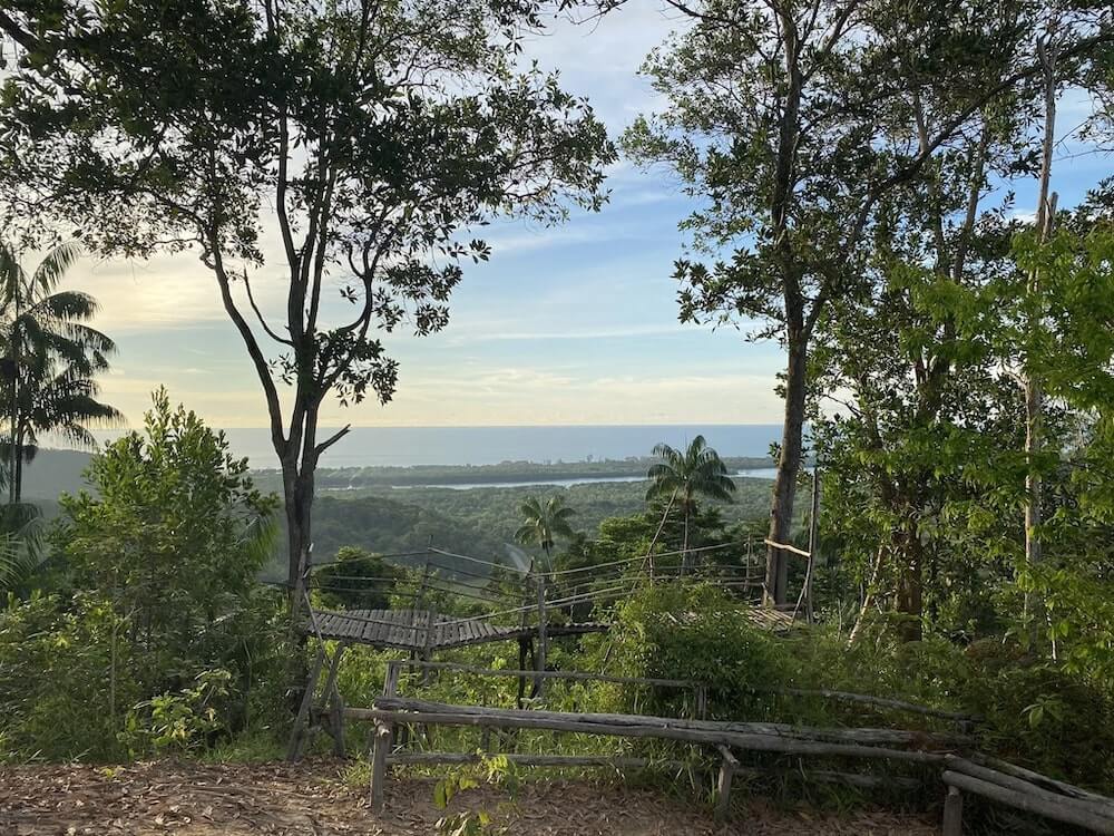
1. Teluk Paku Trail, Bako National Park
Teluk Paku, sometimes known as Telok Paku in the local lingo, is said to be named after the abundant edible ferns that grow within its trail. This particular hiking trail is found in Bako National Park, a national park within the Kuching district of Sarawak that was established in 1957, making it Sarawak’s oldest national park.
A vast variety of endemic Bornean vegetation, wildlife, secluded beaches, jungle streams, waterfalls, and of course, hiking trails, can be found within this land which is currently only accessible by boat. So if you’re looking for adventure just like in the movies, this is one national park you’ll want to allocate a few days for! But you can always keep it to a day trip if you're only interested in this particular trail.
While it’s not as popular as the Teluk Pandan Kecil and Teluk Pandan Besar Trails, the Teluk Paku Trail is the perfect place to spot endemic proboscis monkeys, also known as the long-nosed monkey.

The trail is one of Bako National Park's easier and fun ones that take you through the cliff forest with a small, secluded beach at the trail’s end. While easier, it’s still considered moderately challenging because of how frequent you’ll need to scale and descend the trail’s countless wooden stairs. It’s definitely not one for those with weak knees or knee problems!
It’s a well-shaded trail that tends to get muddy and slippery during the rainy season, so it’s best to plan your trip there during the dry period between April to September. And while it’s well-shaded, some parts on the higher grounds are not particularly shaded so bring a hat and apply ample sunscreen.
Pro Tip: Once you’re at the beach, keep your belongings secured or on you because monkeys tend to frolic there and steal unattended belongings!
Entry Fee: RM10 for MyKad holders, RM20 for international visitors.
Hiking Time: Up to 1 hour 30 minutes
Trail Distance: 2.7km
Elevation Gain: 140m
Opening Hours: 8am - 3pm, daily

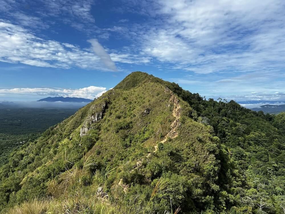
2. Mount Serapi Summit Trail, Kubah National Park (Gunung Serapi)
Enter Kuching’s tallest peak that stands at a majestic 911m above sea level. Mount Serapi is located within the Kubah National Park along with its many trails, but the actual peak is not exactly accessible to the public because of the telecommunications tower that occupies its peak. This means that the hiker’s summit is around the 684m elevation mark, which is still high enough for a rewarding panoramic experience!
Countless rare ferns, orchids, and over 93 recorded palm species can be found on Mount Serapi. Did you know that’s how it got its title “World of Palms”? It’s also home to wild animals like hornbills, squirrels, bearded pigs, mouse deers, and scores of reptiles and amphibians, making it truly paradise on earth for nature and wildlife enthusiasts.
That said, Mount Serapi’s Summit Trail is widely regarded as a challenging hiking trail because of its relentlessly steep 45 degree paved inclines and very few and far in between flat stretches. While this makes it a fun challenge for experienced hikers, beginners may want to keep this in mind before deciding on a day trip to hike up Mount Serapi.

Even though it is a challenging steep trail, the tree canopy provides ample shade to make it a relatively cool one. The hidden waterfalls and small rivers that lie within the jungle also makes it an overall cooling hike.
I’d recommend bringing a hiking stick if you are a beginner or if you have experienced knee problems. This will make the descent a whole lot easier. Not forgetting two or three snacks and at least 2L of iced water in a double wall vacuum insulated water bottle to stay cool, hydrated, and energised during the hike which may go up to 5 and a half hours.
Entry Fee: RM10 for MyKad holders, RM20 for international visitors.
Hiking Time: Up to 5 hours 30 minutes
Trail Distance: Approx 10km
Elevation Gain: 684m
Opening Hours: 8am - 5pm on weekdays, 7:30am - 4:30pm on weekends and public holidays. Hiking cut-off time is at 10am, so begin your hike before that time.

3. Bukit Selang Trail, Kubah National Park
Those who don’t wish to take on the challenge of Mount Serapi in the Kubah National Park will enjoy the fact that there is a much easier hiking trail to enjoy while hiking in Kuching.
Enter the Bukit Selang Trail. This hiking trail is home to a great view that awaits you at its peak while serving as one of the national park’s easier and more popular trails.
It’s a moderately challenging hiking trail because of its steep incline, but the fact that it’s a steady incline makes it a much easier one. You’ll find plenty of rest stops along the way where you can stop to catch your breath and admire the scenery.
Veteran hikers and nature lovers will find this particular trail a leisurely one as it is one of the best known hiking trails for one to enjoy an immersive experience in nature with the sound of chirping birds and rustling leaves amidst its cool forest.
Once you reach the peak, brace yourself for a rewarding view of Kuching’s surrounding agricultural lands, small villages, winding rivers, and mangrove forests by the coastline. If you’re lucky you may even spot the Satang Island Turtle Sanctuary and the majestic Mount Santubong on a clear day!

Because it’s a moderately challenging climb, I’d recommend packing some food like a granola bar or two and enough water for a 2 hour steady uphill hiking session. My personal preference would be about 1L of iced water in the Montigo Ace Bottle Mega to keep my bag light.
Entry Fee: RM10 for MyKad holders, RM20 for international visitors.
Hiking Time: Up to 2 hours 15 minutes
Trail Distance: Approx 4.7km
Elevation Gain: 265m
Opening Hours: 8am - 5pm on weekdays, 7:30am - 4:30pm on weekends and public holidays. Hiking cut-off time is at 10am, so begin your hike before that time.

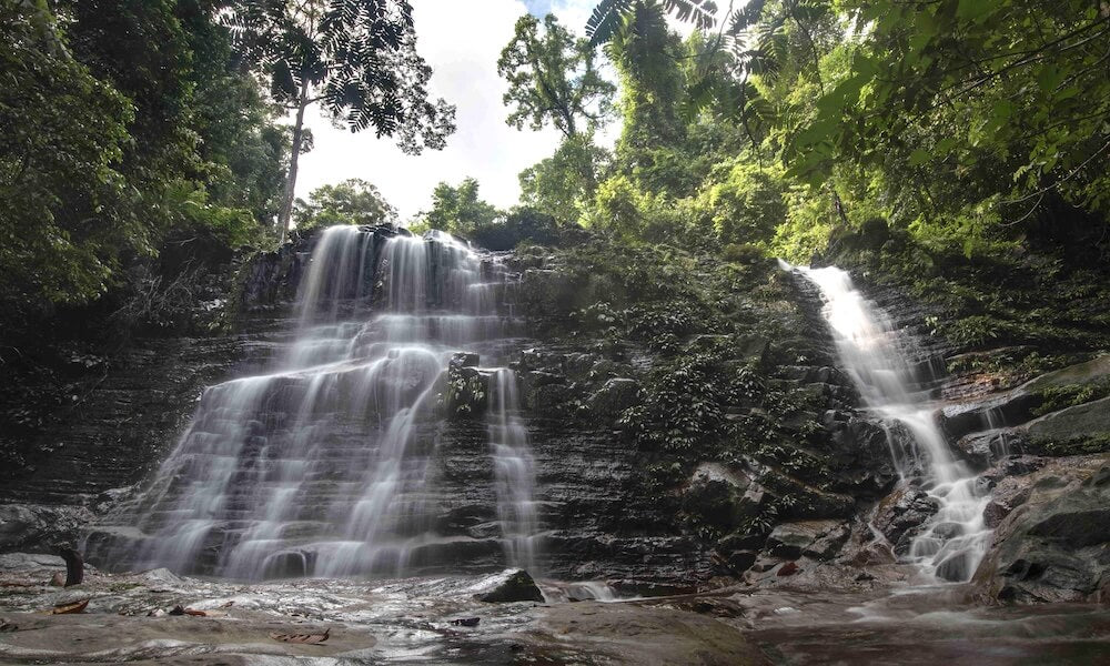
4. Kubah Waterfall Trail, Kubah National Park
You’ll love this one if you’re an adventurous waterfall chaser. The Kubah Waterfall Trail is one of Kubah National Park’s shorter trails, but don’t let that fool you.
Many hikers regard the Waterfall Trail as a moderate to challenging one for a few reasons. Think jungle trekking through numerous plank-walk sections across swampy dipterocarp forest with small jungle streams, followed by steep inclines and challenging climbs that are almost treacherous during wet periods where it’s extra slippery.
Veteran hikers who are physically fit will find this an awesome experience, but beginners may want to think twice about making this trail a part of their first few hiking experiences. Unless you’re up for a truly rewarding challenge.
You’ll encounter wild durian trees along the way as you trek towards the stunning waterfall cascade, where a pool of clear and cool waters await. The best part about hiking here is the fact that you can enjoy a cold, refreshing swim after embracing the challenge.
One thing to be aware of is that there are leeches here because of the trail’s damp nature. So some prepared wearing leech socks and eucalyptus ointment or spray applied to keep those pesky fellas away. You will also want to keep a salt packet handy in case of leech bites.
Entry Fee: RM10 for MyKad holders, RM20 for international visitors.
Hiking Time: Up to 4 hours
Trail Distance: Approx 7.1km
Elevation Gain: 448m
Opening Hours: 8am - 5pm on weekdays, 7:30am - 4:30pm on weekends and public holidays. Hiking cut-off time is at 10am, so begin your hike before that time.

5. Belian Trail, Kubah National Park
If the earlier trails sound a little too daunting at this stage, rest assured that the Belian Trail is the gem you’ve been waiting for.
The Belian Trail is known as Kubah National Park’s easiest trail and a must visit for nature enthusiasts because it is home to the spectacular Belian tree, also known as the Borneo Ironwood tree, one of the finest hardwood trees endemic to Borneo.
This out-and-back trail is mostly a flat stretch across the national park’s elevated plank-walk and soil blanketed by fallen leaves. Hikers can enjoy a slow and relaxing stroll as they immerse themselves in the depths of nature.
Plenty of flora can be found in the forest, such as wild gingers, giant fungus, wild durian trees, wild rambutan trees, and even wild cempedak trees! Having said that, it does sound more like an orchard than a hiking trail huh?
Bird watchers will also enjoy this trail because rare forest birds like the maroon woodpecker, chestnut-naped forktail, and white-rumped shama are often reported to be sighted and heard here.
Entry Fee: RM10 for MyKad holders, RM20 for international visitors.
Hiking Time: Up to 1 hour 30 minutes
Trail Distance: 3.2km
Elevation Gain: 123m
Opening Hours: 8am - 5pm on weekdays, 7:30am - 4:30pm on weekends and public holidays. Hiking cut-off time is at 10am, so begin your hike before that time.

6. Mount Santubong, Santubong National Park
Mount Santubong is Kuching’s second tallest peak at 810m, but that’s not the only thing it’s known for. It’s one of Sarawak’s best kept secrets for being a treasure trove of adventure which you can't miss out on if you want to conquer hiking in Kuching!
Two different exploration routes lie in wait for explorers and hikers to traverse its path. Hikers will have the choice of the moderately challenging Santubong Waterfall Loop Route, or the route to tackle Mount Santubong’s summit for a proper challenge.
The Mount Santubong Hiking Trail is an incredibly challenging one that is recommended only for experienced hikers and those who are physically fit. Simply because the trail is populated with rocky river crossings, 45 degree slopes, makeshift stairways of overgrown roots and rocks to be climbed via knotted ropes, and lastly, a series of steep steel ladder climbs.
Even though it is well-marked and well equipped with several tools installed to assist hikers, it is still a rather treacherous exploration for the unprepared, the unfit, and those with a great fear of heights. But if you are an experienced hiker with excellent stamina and endurance, you’ll find this trail to be one of the most exciting hiking trails in Kuching to be explored.
Should you decide to scale Mount Santubong, I’d recommend bringing at least 2L of iced water and no less along with a first aid kit for the long, arduous journey ahead. Do pack some snacks and maybe a light lunch to enjoy at the summit, where a breathtaking view of the wide Santubong river, Kuching city, and colourful agricultural fields await.

If the summit trail is not your cup of tea, you can always opt for the Waterfall Loop Trail at the lower levels. Rest assured that it is a moderately challenging one with a greater than ever reward at the trail’s end for waterfall chasers to soak away their fatigue in the cool and clear waters after a long, sweaty hike.
Come prepared for the hike with insect repellant, hiking sticks, and leech socks equipped as the damp areas leading to the river and waterfall may at times be infested with leeches.
Entry Fee: RM10 for MyKad holders, RM20 for international visitors.
Hiking Time: Up to 8 hours if you tackle the summit, loop trail and waterfall trail on the same day
Trail Distance: Up to 9km
Elevation Gain: 810m
Opening Hours: 8am - 5pm, daily. Final entry for hikers is at 9am and you must return before or by 4pm.

7. Bung Jagoi, Kampung Duyoh
Did you know that “bung” means “mountain” in the Bornean Bidayuh language? That means “Bung Jagoi” is known as Jagoi Mountain in Bidayuh!
Bung Jagoi is one of Sarawak’s easier mountains to scale that can be found in the Bidayuh village of Kampung Duyoh in Bau, just southwest of Kuching. The trailhead is within the Bidayuh village itself and it will take you through Bung Jagoi’s lush jungle that is filled with countless wild animals and wildflowers which nature enthusiasts will truly appreciate.
It is an easy and fairly straightforward hiking trail with up to 2.5km of staircase to climb, so take it easy and enjoy a slow and steady ascent that matches your physical fitness levels.
Along the way up Bung Jagoi, you’ll encounter bungalow houses and a chapel which indicates that you are close to the summit. I’d recommend bringing enough water to last you through a 2 hour hike along with a snack or two to enjoy at the summit.
That said, there are food and beverage vendors close to the summit so you can skip packing snacks altogether and keep your carry-on light as an option.
Another thing to note is that Bung Jagoi is home to friendly dogs which will at times accompany you along the hike as your very own fur-buddy guide (this alone makes Bung Jagoi one of the best places to go hiking in Kuching!). So bring along a pack of dog treats to make their day, and yours too! ;)
Entry Fee: RM5 entry fee and RM3 parking fee
Hiking Time: Up to 2 hours
Trail Distance: 4.7km
Elevation Gain: 305m
Opening Hours: 8am - 4pm, daily. Closed on Mondays and Thursdays.