


Experience Stunning Natural Beauty Like None Other Simply By Hiking In Sabah
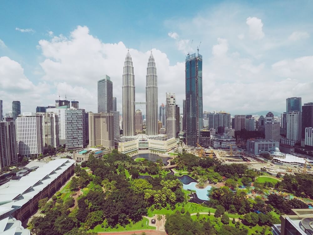
What comes to mind when you think of Sabah? I’ll bet it’s Mount Kinabalu, Kota Kinabalu city, or the pristine waters and turtle population of Sipadan Island.
It’s no surprise because these places are world renowned when it comes to Sabah. But did you know that Sabah is home to countless hills and mountains other than Mount Kinabalu, and natural treasures like a protected 130-million year old rainforest?
And the best part is how you don’t have to be a veteran hiker to enjoy hiking most of these hills and mountains!
So if you have always wanted to experience the beauty of the tropics from both the “top of the world” and the ground, here’s your chance to do so in Sabah, the Land Below The Wind.
Before we begin our adventure, did you know that the capital of Sabah, Kota Kinabalu, was once named Jesselton before it was renamed Kota Kinabalu in 1964?
11 Hiking Trails & Natural Wonders to Explore in Sabah for an Unforgettable Experience in Nature
1. Sosodikon Hill, Ranau
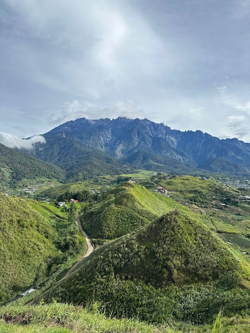
You don’t have to go all the way to Switzerland or New Zealand to take in the view of beautiful pastures and stunning hillscapes when you can do so right here at Sosodikon Hill in Ranau.
This popular destination near the Desa Cattle Dairy Farm in Kundasang is a hiking spot frequented by families and tourists because of the spectacular view that awaits upon reaching the Rainbow Platform at its peak.
The hiking trail leading to the Rainbow Platform is a short one, with the elevation making it a moderately challenging one. Thankfully there are several rest stops along the way for hikers to catch their breath while taking in the beautiful scenery on the way up.
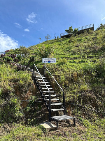
While the trail is a mixture of proper stairs and occasional rocky terrain, it’s also best to go during the dry season as certain parts of the trail involves traversing through the natural dirt path which tends to get slippery and muddy if it rained the day before.
That said, I’d recommend applying sunblock, wearing a hat, and preparing a little umbrella in your hiking bag if you’re starting your hike after sunrise as the trail is not shaded.
Once you’ve descended, you can give your trip a sweet ending with a visit to the Desa Cattle Dairy Farm to enjoy some fresh milk, ice cream, and fresh yoghurt that are all made on-site!
Entry Fee: RM5 for adult and RM3 for children MyKad holders, RM10 for adult international visitors and RM5 for accompanying children
Hiking Time: Up to 20 minutes
Trail Distance: Approximately 400m
Elevation Gain: 1465m
Opening Hours: 6am - 5pm, daily
Address: Kampung Kauluan Peti Surat 873, 89308, Kundasang, Sabah
2. Bukit Perahu, Tamparuli (a.k.a. St. Veronica’s Hill)
20 minutes away from Kota Kinabalu and just outside the small town of Tamparuli lies Bukit Perahu, also known as St. Veronica’s Hill. Bukit Perahu got its name from the locals, who named it as such because of the inverted boat-shaped rock that sits near its summit’s clearing.
Bukit Perahu is considered one of the local’s favourite haunts to keep fit or to build their endurance before attempting to hike Mount Kinabalu. It’s a moderately challenging hiking trail because of the sheer number of steps you have to conquer, even with knotted ropes present throughout to make the ascend a little easier.
Because the steps are made from concrete, it’s best to go only during the dry season as you don't want to be stuck with its slippery terrain.
Once you reach the peak, you’ll be rewarded with a scenic view of Tamparuli town, Mount Kinabalu on the other direction, and the misty lowlands if you reach the peak little before sunrise.
One of the best things you could do to make the (sometimes) torturous climb a little easier is to pack cold water in a vacuum insulated water bottle and enjoy brief, refreshing sips as you complete a certain set of steps. Not to mention that the peak is not shaded, so don your favourite outdoor hat and keep an umbrella handy if you think you’ll reach the peak anytime around 10am onwards.
Bonus Tip: The real secret of this hill is the view of the stunning sunrise. So pack your headlamp and/or torchlight and start your hike before sunrise to enjoy the majestic sights.
Hiking Time: Up to 1 hour 15 minutes
Trail Distance: 1.6km
Elevation Gain: 260m
Opening Hours: 24 hours, daily
Address: Bukit Perahu, 89250 Tamparuli, Sabah
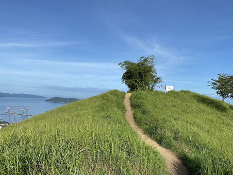
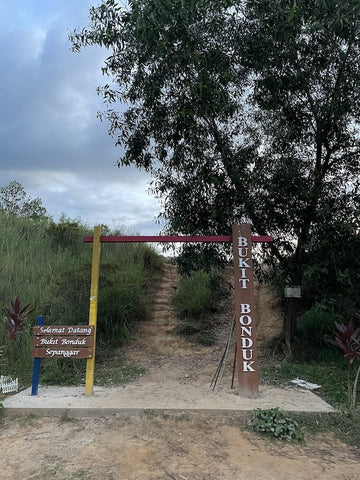
3. Bukit Botak, Kota Kinabalu (a.k.a. Bukit Bonduk)
Those familiar with the Malay and Indonesian language will know the meaning behind Bukit Botak’s name. But for those who don’t - botak means bald in English, and it is named as such because the hill looks rather bald from afar.
Bukit Botak is a hill located just along the outskirts of Kota Kinabalu and it is fondly known by the locals as Bukit Bonduk. It’s a bushy hill that houses one of the more popular hiking trails for those seeking to build up their stamina and endurance before attempting to hike Mount Kinabalu because it is the easier alternative to Bukit Perahu.
The hiking trail here is a lightly trafficked out-and-back trail that is well known for the view of the sunset at its peak, along with a panoramic coastal view of the sea port, Kota Kinabalu International Airport, and Pulau Gaya which is just 10 minutes away by ferry from Kota Kinabalu.
Even though it is lightly trafficked, the hiking trail is well-maintained and marked so veteran hikers will find it an easy hike while beginners may find it challenging as the trail is sandy and steep, making it a slightly slippery climb. Wear worn-in hiking shoes with a strong grip and bring a hiking stick to make your climb an easier one. You’ll also occasionally encounter large trees with overgrown roots, so watch your step and take care not to trip. On the brightside, these roots do help by serving as makeshift stairs.
The peak is exposed along with most of the trail (hence its namesake), so I’d recommend bringing an umbrella or wearing a hat, and applying ample sunblock to keep those pesky UV rays away. And if you’re not a regular hiker, pack enough water and an energy bar or two for the hike - it will come in handy.
Hiking Time: Up to 1 hour 20 minutes
Trail Distance: 3.1km
Elevation Gain: 231m
Opening Hours: 7am - 6pm, daily
Address: Bukit Botak, 89200, Kota Kinabalu, Sabah
4. Matanoi Hill, Keningau
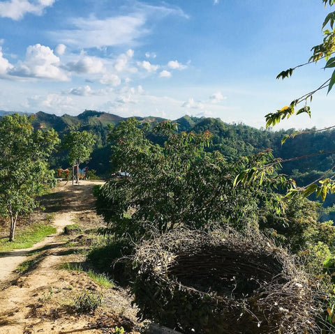
Enter a fun hiking trail that’s home to Malaysia’s version of the highly popular IG-worthy Bird’s Nest Spot in Bali. So if you can’t yet make the trip to Bali for whatever reason, you’ll want to check this place out.
Matanoi Hill is a recreational place with multiple hiking routes in various difficulty levels for hikers to attempt and an absolutely lovely Rabbit Farm for all to enjoy at its foothill. It is found approximately via a 2 hours and 15 minutes drive south from Kota Kinabalu in the town of Keningau.
There are a total of three trails here: Trail A being the shortest yet steepest trail, Trail B being the longest yet easiest trail at a leisure pace, and Trail C being between both in terms of difficulty. If you’re only there to get the coveted photo in the bird’s nest and to enjoy the stunning views, then I’d recommend taking Trail B, and Trail C if you’re after a slight challenge.
Hiking Time: Approximately 30 minutes
Trail Distance: 1km
Elevation Gain: 71m
Opening Hours: 6am - 6pm, daily
Address: Jalan Apin-Apin Bundu, Kampung Tiga, 89650, Keningau, Sabah
5. Bukit Kopungit, Kota Kinabalu
Looking for a quick getaway from the city without having to actually leave the city? Bukit Kopungit in Kota Kinabalu is the answer! This hill is popular amongst the locals as a spot for them to bring their teenage children out for a fun family activity to keep fit while familiarising them to the beauty of the great outdoors, and to catch the sunrise and sunset.
It also holds a status as Kota Kinabalu’s iconic hill because it is home to historic bunker tunnels along the hiking trails, and these date back all the way to the time of the Japanese occupation during World War 2.
Bukit Kopungit is moderately challenging in terms of difficulty as the paths can be steep, so avoid it during rainy periods as the mixture of rugged dirt paths will make it dangerously slippery to attempt. There’s also a fun section of the hiking trail that is a steep pathway made entirely out of old car tyres to serve as a set of makeshift staircase with a rope knot to help hikers scale a little easily.
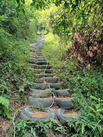
Beginners can enjoy walking the easy trail that leads directly up to the peak in under 15 minutes. But having said that, it is still rather steep so do bring a hiking stick to experience an easier descent. Veteran hikers seeking a challenge may opt for the lengthier loop to enjoy a full exploration of Bukit Kopungit and its hidden treasures.
Hiking Time: Up to 2 hours, depending on fitness levels
Trail Distance: 1.8km
Elevation Gain: 120m
Opening Hours: 24 hours, daily
Address: Bukit Kopungit Trailhead along Jalan Pintas, 88200, Kota Kinabalu, Sabah
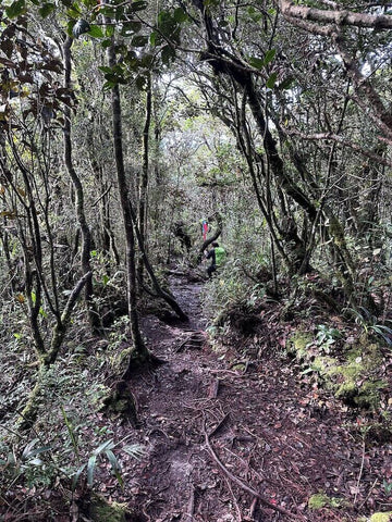
6. Maragang Hill, Kundasang
Remember how Sosodikon Hill is the close equivalent to Switzerland and New Zealand with its picturesque view? Maragang Hill comes a close second as it has one of, if not the best, breathtaking panoramic views of Mount Kinabalu, which is said to be its nearest hill.
Maragang Hill is one of the best hiking trails for those who seek to experience the natural beauty and biodiversity of Sabah and it is also known as the Mossy Forest of Borneo. (Hands up if you’ve been to the Mossy Forest in Cameron Highlands!)
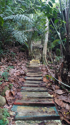
The hiking trail here is moderately challenging thanks to its slightly mossy and undulating terrain which alternates between gentle slopes and steep ridges. It’s best to come ready with a hiking stick, hiking shoes with excellent grip, and your headlamp as it tends to be dark due to the forest’s dense nature.
The atmosphere at Maragang Hill is unlike Malaysia’s general tropical climate. Think temperatures that fall as low as 20°C thanks to its elevation and dense foliage. It’s also said to be a good spot to catch the sunrise, but the journey can be incredibly windy and cold during the wee hours of the morning. There are stargazers who’d even stay up top until dark simply to photograph the milky way, so you can just imagine the view!
What separates Maragang Hill from most of the other hills in Sabah is how you need to book your hike in advance with the Maragang Hill Team and allow them to confirm receipt of your booking request even before you show up to register and get your permit at the admin office of Maragang Hill in Kampung Mesilou. Failing to do so will net you a hefty fine as it is a privately-owned land that is well-taken care of by the local community cooperative. This also means that you’ll get a truly informative hike as you’ll be provided a local guide to walk you through while detailing the native flora and fauna found here such as the red leaf monkeys, pitcher plants, native orchids, and more.
Lastly, you’ll want to ensure you pack enough water and food as it is a lengthy hike. I’d recommend at least 1.5L of drinking water to stay hydrated and pack some energy bars or fruits like bananas, apples, or even granola bars.

Hiking Time: Up to 2 hours, depending on your fitness level
Trail Distance: 2.6km
Elevation Gain: 342m
Opening Hours: 6am - 2pm on Mondays to Thursdays, 6am - 1pm on Fridays, and 2am - 3pm on Saturdays and Sundays
Address: Maragang Hill Registration Center, Kampung Mesillou, 89308, Kundasang, Sabah

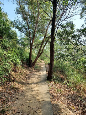
7. Bukit Tirig, Kota Kinabalu
Bukit Tirig is a fan favourite for locals who have just gotten into hiking because of how relaxing its hiking trail is. It’s known as one of the easiest hills to hike in Kota Kinabalu and is found just under an hour’s drive north of Kota Kinabalu.
The hiking trail is an easy to moderate trail with a terrain that is a mixture of shaded forest pathways and exposed dirt paths. You’ll find the occasional overgrown tree roots blanketing the way so remember to watch your step there!

Once you reach the peak, there is a gazebo for hikers to take a break while marinating in the rewarding panoramic view that comprises of Mengkabung Bridge, the sea, and even Mount Kinabalu on a clear day. Since there’s a gazebo you can chill at, I’d recommend bringing a snack or two to have a fun little picnic there as a reward for reaching the peak.
Hiking Time: Up to 1 hour
Trail Distance: 1.6km
Elevation Gain: 132m
Opening Hours: 24 hours, daily
Address: Bukit Tirig, 89200, Kota Kinabalu, Sabah

8. Bukit Bongol, Kota Belud
Welcome to one of Kota Belud’s most famous hills because of its multi-peak landscape and movie-like grassy fields that appear almost golden during sunset. Those who’ve hiked Broga Hill before will find this somewhat familiar. It’s also one of the best mountains to hike if you make it a point to avoid crowds.
Bukit Bongol is a moderately difficult out-and-back hike with multiple trails, namely the Pirasan trail, Kinasaraban trail, and Kampung Mantap trail. While they are separate trailheads, they lead to the same peak. Expect to hike through a dense forest and fields blanket by ferns before you reach the peaceful clearing at its peak.
That said, do come prepared with a hat because the peak and most parts of the hiking trails are not shaded. And lastly, avoid this place if your knees aren’t in top form as there are proper steep inclines.
Entry Fee: RM3 for adults and RM2 for children
Hiking Time: Up to 2 hours
Trail Distance: 2.7km
Elevation Gain: 354m
Opening Hours: 24 hours, daily
Address: Bukit Bongol, 89150, Kota Belud, Sabah
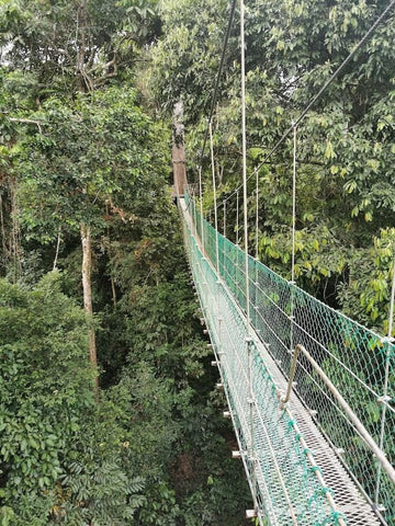
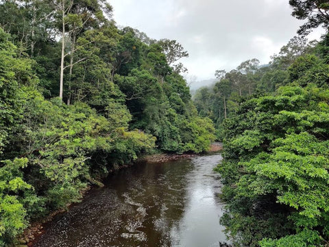
9. Danum Valley, Lahad Datu
Danum Valley is one of Sabah’s hidden gems and also one of the world’s most untouched rainforest that has existed for over 130 million years. It’s a lowland rainforest that is home to countless endemic rare wildlife species such as the clouded leopard, endangered Bornean pygmy elephant, flying lemures, slow loris, and more. Think of this dense jungle as a total paradise for wildlife enthusiasts and nature lovers.
It is approximately 80km away from Lahad Datu, a small town located in the east coast of Sabah and serves as the home for one of the world’s tallest tropical trees and the Danum Valley Field Centre (DVFC).
Those seeking to explore Danum Valley must book ahead with a licensed guide as only guided explorations are permitted in the area. The tour package options often range between 3 days and 2 nights to 5 days and 4 nights, with a number of rainforest lodges there to serve as your accommodation.
Danum Valley is also famous for outdoor activities like its suspended rope bridges, which is truly the best way to see wildlife here. On the flipside, brave souls will enjoy the guided night safari exploration on a four-wheeler as you can spot rare nocturnal species such as the sambar deer and civets.
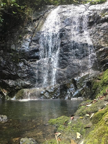
If you’re a waterfall chaser, you’ll love how the Borneo rainforest is home to stunning waterfalls you can bathe in during your guided tour.
Having said that, bear in mind that this valley is home to countless leeches thanks to its damp nature, so wear leech socks and apply eucalyptus oil to keep yourself as leech-free as possible.
Opening Hours: 24 hours, daily
Address: Danum Valley Conservation Area, Lahad Datu , Sabah
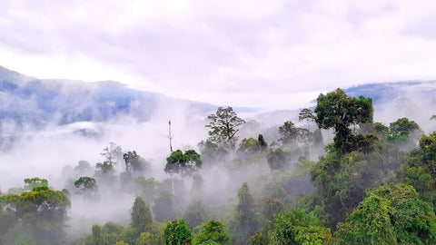
10. Maliau Basin, Kota Kinabatangan
Cousin to the Danum Valley, Maliau Basin is a more elusive rainforest that is found deeper in the heart of Sabah. This basin is known as Sabah’s Lost World as it is a naturally occurring, self-contained ecosystem that has never been permanently inhabited nor fully explored. It was only discovered in 1980, which makes it relatively new in the world’s discovered rainforest scene.
It’s even older than Danum Valley, and because of how remote it is, you can truly experience the sheer serenity of nature, be it through its beautiful call or natural sounds. Not forgetting how the air of its lush forests is fresher than ever. Countless rare and endemic flora and fauna can be spotted here during your guided tour, making it similar to Danum in that only guided tours with an experienced guide are permitted here.
The trek through the Bornean forest is only recommended to experienced hikers and experienced explorers as the journey within is long and wrought with consistent inclines and slippery mud paths. It’s fair to say you’ll be expected to cover up to 10km in distance per day!
So while a guided jungle trekking tour through Maliau Basin is definitely an unforgettable, once-in-a-lifetime activity, it definitely is not for the faint-hearted. Especially if you aren’t a nature enthusiast!
Opening Hours: 24 hours, daily
Address: Accessible through Maliau Basin Reception and Information Building along Jalan Tawau Keningau, Kota Kinabatangan, Sabah
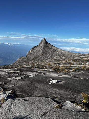
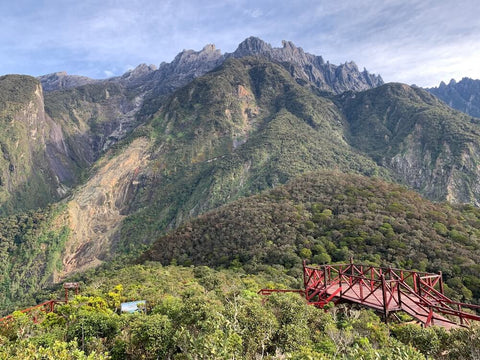
11. Mount Kinabalu
Famous worldwide as the 3rd highest peak in the world at 4095 metres above sea level, the majestic Mount Kinabalu is the highest mountain in Borneo and Malaysia. Don't be surprised when we say that most veteran hikers and mountain climbers have the dream to climb Mount Kinabalu in their bucket list.
Mount Kinabalu is found in Ranau at the West Coast of Sabah and it is protected as a World Heritage Site by UNESCO. It’s home to several hills and hiking trails, making it one of the most exciting adventure zones for avid hikers and explorers.
The legendary mountain itself is famous for its stunning granite summit where most hikers who successfully summit will take the iconic photograph with the Malaysian Ringgit, which also features the very same peak.
Hiking Mount Kinabalu is not for the inexperienced and faint hearted as there are dangerous hurdles and obstacles such as the hanging suspension bridge and steep inclines that go up to 90-degrees, to name a few.
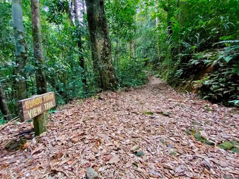
Outdoor enthusiasts who don’t wish to summit can check out the Kiau View Trail which connects to the Silau Silau Trail for a breathtaking view of the surrounding landscape. Alternatively, the free and easy Bundu Tuhan trail is also accessible to beginner hikers who seek to enjoy a brief, 15 minute walk in nature just below Mount Kinabalu.
Elevation Gain: 4095m
Opening Hours: 7am - 5pm, daily
Address: Mt Kinabalu National Park, Kinabalu Park, 89300, Ranau, Sabah