


Hiking Johor 101: The Malaysian State For Epic Adventures Through Untamed Landscapes And Natural Wonders
When most Malaysians think of Johor, a few things come to mind. Laksa Johor (we Malaysians do love our food!), LEGOLAND Malaysia, and the Johor Premium Outlet are perhaps one of the most popular.
But did you know that Johor is home to untamed landscapes and natural wonders that will ignite hearts of the adventurous explorers among us?
From winding paths that lead to hidden waterfalls to dense jungles and rugged trails that ascend to stunning vistas, Johor is a treasure trove of top-notch hiking trails just waiting to be explored.
Whether you’re a seasoned hiker or an spirited adventurer seeking a thrilling escape from city life, these hiking trails in southern peninsular Malaysia promise challenge, discovery, and wonder.
It’s time to lace up your hiking boots, get your comfiest activewear on, and arm yourself with a hiking stick or two, because we’re going to explore the top hiking trails in Johor!
Top 7 Hidden Gems and Hiking Trails in Johor for an Epic Adventure to Remember

1. Bukit Cinta, Jementah
Bukit Cinta is one of the top hiking trails in Johor to catch the sunrise and sea of clouds. Local Johorians can often be found enjoying a leisurely hike to its summit during the weekend thanks to its relatively easy difficulty.
The Bukit Cinta hiking trail is mostly made up of a paved concrete roads with gentle inclines all the way to the summit. It is partly shaded and partly exposed, so I’d recommend wearing a hat to make your hike a comfier one with as little glare as possible especially while enjoying the view at the summit.
What awaits you at the peak is a stunning scenic view of Mount Ophir (also known as Gunung Ledang), vast greenery that blankets the surrounding hills, and the town of Jementah in the Segamat District of Johor. You’ll also spot Bukit Cinta’s signature wrought iron structure that reads “I ♡ U”.
Fun Fact: The signage reads “I ♡ U” because “cinta” in the local Malay language means “love”, hence the structure and the hill’s name!

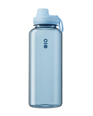
Since this is a simple hike, I’d recommend packing only 1L of iced water in the Montigo Ace Bottle Mega just to keep you cool and hydrated through the hike. The Ace Bottle is truly such a handy water bottle that keeps your water icy cold up to 24 hours, so you don’t have to worry about looking for the nearest convenience store or kopitiam to get your cool beverage fix before and after the hike.
Hiking Time: Up to 1 hour 45 minutes
Trail Distance: 4.2km
Elevation Gain: 241m
Opening Hours: 24 hours, daily
Address: Bukit Cinta, 85200, Jementah, Johor

2. Bukit Jementah
Surprised? Bukit Jementah is part of the twin peaked mountain found in Jementah, which is made up of Bukit Cinta and Bukit Jementah. This gives you the choice to either scale one summit or explore both Bukit Cinta and Bukit Jementah in a day. If you do opt to conquer both trails in a day, you’ll start at Bukit Cinta’s base and end with Bukit Jementah as the final summit.
The Bukit Cinta - Bukit Jementah trail is a highly popular trail for locals especially during the weekends to stay active, catch the sunrise, and enjoy fresh air in the great outdoors. You may even spot the occasional kite-flier on clear, windy days!
Since Bukit Jementah is located near a durian orchard, the scent of ripe durians will likely be wafting through the air especially during durian season between June to August.
Bukit Jementah offers hikers an easy to moderate climb due to the higher frequency of gentle slopes on both tarmac road and rugged dirt stretches. This means beginners can also enjoy this hiking trail! That said, you will encounter occasional steep inclines which will slightly bump up its difficulty, but it’s nothing too daunting.
The only downside of Bukit Jementah is that it’s a mostly exposed trail, so come prepared with heaps of iced water, ample sunblock applied, and a hat to keep yourself shaded from the glaring sun. You’ll also want to pack a snack or two to enjoy on the benches at the summit!
Hiking Time: Up to 1 hour 10 minutes
Trail Distance: 3.1km
Elevation Gain: 178m
Opening Hours: 24 hours, daily
Address: Bukit Jementah, 85200, Jementah, Johor

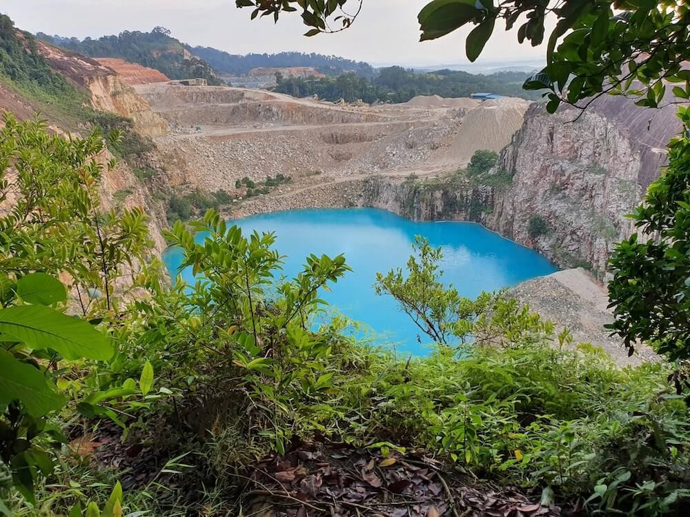
3. Kangkar Pulai Blue Lake via Gunung Pulai Recreational Forest
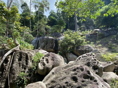
Looking for a scene straight out from a dream? Then you won’t want to miss out on this hidden gem. Johor is home to the Tasik Biru Kangkar Pulai, which means “blue water lake of Kangkar Pulai” in the local Malay language.
The Kangkar Pulai Blue Lake is a stunning hidden gem found deep within the Gunung Pulai Recreational Forest which you can access through the Taman Awak BBKP trailhead to begin your little adventure.
You’ll be able to easily identify the enchanting lake thanks to its signature striking turquoise-blue hue and the limestone quarry that contains it. It’s not a swimming pool and it is not safe for swimming because it used to be a mining pool during the bygone days.
What you can do is enjoy a short, leisurely hike to enjoy sights of the lake and capture a few photographs to remember your moment there. On bright, sunny days, you can spot a truly marvelous sight of the limestone quarry’s reflection on the lake’s surface as if it is a mirror.
The Kangkar Pulai Blue Lake hiking trail is short and easy with mild elevation. It begins as a brief trek through the jungle, followed by a rocky path before arriving at the blue lake. This particular hidden gem of a trail is one of the most beginner-friendly trails in Johor Bahru so even if you feel like you’re not the fittest around, this trail is still very much do-able for a chill hike.
Pro Tip: Remember to charge your phone before embarking on the hike to the Blue Lake. It’s truly a breathtaking view you won’t want to miss out on photographing!
Hiking Time: Up to 1 hour 15 minutes
Trail Distance: 1.8km
Elevation Gain: 76m
Opening Hours: 24 hours, daily
Address: Taman Awam Bandar Baru Kangkar Pulai, Johor Bahru, Johor

4. Buaya Sangkut Waterfall at Endau Rompin National Park
One of Malaysia’s most impressive waterfalls can be found within the Endau Rompin National Park, a forest reserve located between the state of Pahang to Johor - which is also where it got its name! This forest reserve contains some of the world’s oldest rainforests, and because of its protected nature you can’t traverse it without a guide (you can get one assigned to you or your hiking group of no more than 10 pax at the entrance).
The Endau Rompin National park is home to some of the most challenging and best hiking trails in Johor which can span up to several days of exploration for the adventurous ones who want to explore most of the rainforest and encounter waterfalls beyond the Buaya Sangkut Waterfall like the Takah Tinggi Waterfall. If that sounds like you, then you’ll be glad to know that the vast national park is also home to the National Park Chalets for those after a boujee stay, or the National Park Dorms for those looking forward to a backpacking experience.
Having said that, what we’re after here today is the Buaya Sangkut Waterfall - one of Malaysia’s most impressive waterfalls. The Buaya Sangkut Waterfall trail in particular is renowned for its challenging nature.

You’ll begin the trek at the Kuala Marong campsite, which then takes you through steep climbs, slippery treks, and muddy pathways, especially so during the rainy period. Rest assured that knotted ropes are present throughout the climb to assist with your ascend.
The hiking trail’s typically wet nature means that you’ll encounter heaps of leeches, so I’d advise you to come prepared with leech socks equipped, packets of salt, and eucalyptus ointment applied on the lower half of your body to keep most of them at bay.
According to most hikers who have ventured through the dense jungle, you’ll need at least 2.5L of water to keep you hydrated through the long trek along with some food and snacks to keep your energy levels up.
All the challenges you’ll face on the way to the waterfall will be well worth it because what awaits you is a majestic waterfall cascade with a plunge pool at its base. Just imagine how wonderful it would feel to enjoy a dip in its cool and clean waters after the long hike!
Hiking Time: Up to 5 hours
Trail Distance: 17.1km
Elevation Gain: 634m
Opening Hours: 24 hours, daily
Address: Endau Rompin Peta Johor National Park, Ulu Mersing, Endau, Johor

5. Gunung Muntahak
Gunung Muntahak is perhaps an odd-bird among the hiking trails that are found in and around Johor. This hiking spot is not known for the views at the summit, but rather the iconic Tengkil Waterfall located deep within its mountainous terrain and lush vegetation.
Fun Fact: Did you know that the Tengkil Waterfall is said to be the water source for the famous Kota Tinggi Waterfall in Kota Tinggi, Johor? Unfortunately the Kota Tinggi Waterfall has been closed since 2019 until further notice for restoration works due to a flood that badly damaged its infrastructure.
Gunung Muntahak remains largely unexplored because of its non-commercial status, which thankfully keeps most of the primary rainforest untouched. Wildlife enthusiasts will relish this fact because it means that the rainforest will certainly be rich in various unique flora and fauna.
Having said that, Gunung Muntahak poses as one of the more challenging day treks in Johor thanks to its significant distance and relatively steep hills as one of the highest peaks in Johor. Not forgetting the occasional river treks, which means getting partially soaked.
Once you’ve scaled through the dense forest, what awaits you is a chance to treat yourself to a refreshing swim in the fresh mountain waters of Tengkil Waterfall’s pool.
Ultimately the best way to enjoy this hiking trail is to engage a local guide to ensure you don’t lose your way, while also allowing yourself the opportunity to learn of the diverse flora and fauna species that make up Gunung Muntahak’s beautiful scenery.
Hiking Time: Up to 7 and a half hours
Trail Distance: 20.8km
Elevation Gain: 920m
Opening Hours: 24 hours, daily
Address: Gunung Panti Recreational Forest, 81900, Johor

6. Gunung Lambak
Gunung Lambak makes the list as one of Johor’s most popular hiking trails because of the breathtaking panoramic view at its summit. It’s also one of the most accessible hiking spots around with it being just an hour away from Johor and being accessible via the majestic Gunung Lambak Recreational Forest. This means you can stop by Kluang town for a cup of the town’s specialty Kluang Rail Coffee before you embark on your hike.
Gunung Lambak’s hiking trail is a relatively long distance that begins near the Gunung Lambak Water Park on an easy note, which quickly rises in difficulty due to the steep inclines littered throughout the trail.
The inclines are steep to the extent where you need the assistance of knotted ropes to successfully scale it. All in all, Gunung Lambak’s terrain is a mixture of steep climbs, long stretches of stairs, and rugged rocky pathways to be traversed.
Its hiking trail is mostly shaded so you don’t have to worry about being exposed to harsh sun rays for most of the hike. But do take into account Malaysia’s overall humidity by coming prepared with ample cold water to stay refreshed and cool during the long trek.
Once you reach the peak, you’ll be greeted by a signboard that reads “TAHNIAH ANDA BERADA DI PUNCAK GUNUNG LAMBAK”, which means “congratulations, you’ve made it to the peak of Gunung Lambak”. Here’s where you can enjoy a little siesta while taking in the panoramic view of Kluang town, lush green hills that surround Johor, and if you’re lucky, a sea of clouds.
Since the hike stretches over 5 hours depending on your hiking group’s fitness levels, I’d recommend bringing at least 2L of ice cold water in the Montigo Ace Bottle Massive, a small lunch pack or sandwich, and some fruits like bananas and apples to keep your energy levels up.
Hikers have occasionally reported leech encounters especially during the rainy season, so do come prepared with leech socks equipped and eucalyptus ointment applied. Don’t forget your salt packets too!
Hiking Time: Up to 5 hours
Trail Distance: 6.1km
Elevation Gain: 746m
Opening Hours: 24 hours, daily
Address: Gunung Lambak Water Park, Kampung Dato Abdul Rahman Yassin, 86000 Kluang, Johor

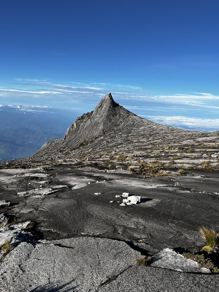
7. Mount Ophir, a.k.a. Gunung Ledang
Enter the site of the famous ancient Malay folklore and ancient myths of rich gold deposits, Mount Ophir, also known as Gunung Ledang. Most millennials and the generation before will recall the story of “Puteri Gunung Ledang” which was told countless times during primary schooling days and earlier. Well, this is the very same mountain!
Mount Ophir is known as a popular tourist destination for local history buffs and folklore enthusiasts, and for being home to one of the most difficult hiking trails in Johor. It is also the 6th most challenging mountain to climb in Malaysia at up to 1,295m elevation.
Hiking Mount Ophir is only recommended for trained adventurers, veteran hikers, and highly experienced explorers because of its intense difficulty. The Mount Ophir trail starts at Taman Hutan Lagenda where you can complete your registration and get a guide assigned to you or your hiking group as a whole before embarking on the hike. Do note that you absolutely cannot proceed with the hike if you don’t have a trekking permit and a guide with you.
What makes Mount Ophir extremely challenging are the dense jungle trek over gnarled tree roots that serve as stairs, gruelling stretches of steep ladder assisted climbs, almost 90-degrees knotted rope climbs over smooth rock slabs, and rocky pathways to navigate through.

You’ll encounter a diverse range of exotic flora and fauna along the trek, so hikers who are also nature enthusiasts will truly enjoy the adventure. The species of flora include rare and unique wild orchids, native pitcher plants, and more. As for fauna, you may spot wildlife such as monitor lizards, wild boars, monkeys, and exotic birds nesting in the surrounding trees such as the critically endangered Helmeted Hornbill and Stripe-throated Bulbul. With wild boars present in the vicinity, you’ll naturally encounter leeches so the usual protocol of leech socks, eucalyptus ointment, and salt packets apply.
The summit of Mount Ophir is a truly breathtaking sight to behold. Up top you’ll enjoy views of the Strait of Malacca which connects the Andaman Sea and South China Sea, and panoramic views of Johor.
Since the hike takes up to 11 hours to complete depending on you and your hiking group’s fitness levels, do bring ample water (hikers have reported that you should bring no less than 3L of water), and enough food to lasts through the hike - this means some energy bars, a lunch pack, and some fruit. That’s because the climbs WILL make you absolutely famished.
Hiking Time: Up to 11 hours
Trail Distance: 10.5km
Elevation Gain: 1,295m
Opening Hours: 24 hours, daily
Address: Gunung Lambak Water Park, Kampung Dato Abdul Rahman Yassin, 86000 Kluang, Johor