


Experience Diverse And Natural Beauty By Hiking In Negeri Sembilan
Believe it or not, Negeri Sembilan has plenty of breathtaking hiking trails from the historic Royal Air Force B-24 Liberator crash site and Gua Kambing at Gunung Berembun to the famous 40-metre-wide wave rock of Bukit Putus!
You get to explore the great outdoors of Malaysia, surrounded by the lush greenery, as you inhale crisp fresh air, far away from the stress of the city. All with a chance to experience rewarding sights that promise bragging rights. ;)
Which is why hiking in Negeri Sembilan is a fantastic way to escape the hustle and bustle of the larger cities without breaking the bank.
If you're ready for your outdoor adventures at the hiking trails of Negeri Sembilan, get your hiking friends together, lace up your hiking shoes and pack your essentials for a hiking trip through this sleepy state in Malaysia!
11 Exciting Hiking Trails To Explore In Negeri Sembilan (Complete With A Tough Hike For Experienced Hikers!)

1. Broga Hill, Selangor
Yes, Broga Hill is in Seminyih, Selangor. But since it borders Negeri Sembilan and it is the local resident's favourite hiking spot, I simply could not write this article without mentioning Broga Hill!
You need to obtain a permit from the Selangor Forestry Department's website by filling up a form and paying RM5 per person at least one week before the day you intend to climb Broga Hill.
Two routes will lead you to the first peak. The old route is through the opening of the fence to the left side of the signboard, while the new route is under the signboard. You may find the last leg of the trail to be rather slippery, so I'd recommend wearing proper hiking shoes with strong anti-slip soles to ease your climb.
Upon reaching the first summit, you'll get the chance to continue climbing ahead to the second and third hills. The first and second peaks offer stunning views of the surrounding plantations and towns, while the view from the third peak is partially blocked by trees and rocks, which is perfect if you're looking for an extra challenge!
If you're hiking Broga Hill soon, do pack your insect repellent and a hat. You might also want to bring your raincoat in case of rain because Broga Hill's unshaded terrain offers little to no shelter. And since it's a very popular place to watch the sunrise, be prepared to see many hikers on your way up.
Entry Fee: RM10 = RM5 (parking) + RM5 (permit)
Hiking Time: 1 hour 18 minutes
Trail Distance: 2.8km
Elevation Gain: Up to 283m
Opening Hours: 4:00 AM to 6:30 PM, daily
Address: Jalan Broga, 43500, Semenyih, Selangor

2. Melati Hill, Bandar Baru Nilai
Melati Hill is a famous hiking spot that offers a range of hiking trails in Negeri Sembilan that range between easy to moderate in difficulty, namely the Eagle Hill, Monkey Hill, Centipede Hill, Cobra Hill, and Mosquito Hill.
Public toilets and refreshment stalls can be found at Melati's foothill, with the latter being available only during weekends. This also means that it tends to get crowded, so I'd recommend attempting your hike during the weekdays if you prefer quiet hikes. And bear in mind that certain areas have heaps of mosquitoes, so don't forget your mosquito repellent!
Melati Hill's trailhead begins at Eagle Hill, which starts from the left of the temple. It begins flat before you walk down through the tall palms. Along the way, you will also see monkeys and signs of wild boar tracks.
The trail eventually leads you to a junction where you can take other trails to continue your exercise. There are ropes throughout these trails for you to use throughout your hike, which is especially useful if the ground is slippery.
Entry Fee: Free
Hiking Time: 1 hour 12 minutes
Trail Distance: 3.5km
Elevation Gain: 169m
Opening Hours: 24 hours, daily
Address: Bandar Baru Nilai, 71800 Nilai, Negeri Sembilan

3. Kepayang Hill, Taman Bukit Kepayang (Bukit Kepayang)
Bukit Kepayang may be a small hill in Negeri Sembilan but don't underestimate it. This hill is home to several easy to moderately challenging hiking trails that even include navigating through rocky terrains with assisted rope climbs!
For instance, the Super Way Trail is pretty steep but it is the fastest way up to the peak. But many of these trails intersect, so you can go for a few trails when you're here!

Although it's not a tall hill, you will still be amazed by the gorgeous scenery at the peak. The peak is a spacious area that is perfect for picnics as you enjoy the surrounding nature, so pack a refreshing chilled beverage in your Montigo double-wall insulated water bottle which will keep your drinks cold up to 24 hours, and a delicious snack or two before you embark on your hike for a truly fulfilling day!
Entry Fee: Free
Hiking Time: 1 hour 8 minutes (almost 6 hours for all trails!)
Trail Distance: 3.4km (up to more than 10 km if you want to try all trails in one go!)
Elevation Gain: 159m
Opening Hours: 24 hours, daily
Address: Jalan Taman Bukit Kepayang Besar 1, Taman Bukit Kepayang, 70200, Seremban, Negeri Sembilan

4. Bukit Batu Sawa, Peradong
If you're new to hiking, beginning your journey at Bukit Batu Sawa is a great start! To hike here, you'll need to get a permit in advance from the Negeri Sembilan Forestry Department.
Your journey starts on a narrow dirt road which is a short walk from a rubber plantation. It begins with mostly gentle slopes and flat grassland, where you will see signs of wild boars in the area.
Once past the grassland, it's time for a steep climb where there are two roped sections.
Even before you reach the peak, you'll see ample beauty along the way. Eventually, you'll reach the crushed limestone trail, lined with beautiful tall trees with rich red bark.
Once you reach the top of the hill, you will be rewarded with spectacular views of greenery and blue skies without going on a tough hike!
Entry Fee: RM5
Hiking Time: 1 hour 21 minutes
Trail Distance: 3.5km
Elevation Gain: 210m
Opening Hours: 24 hours, daily
Address: Peradong, Negeri Sembilan

5. Gunung Datuk, Kota
If you're looking for a real challenge, look no further. Gunung Datuk is just the place for you to hike! Even though it's a tough hike to the peak, the spectacular 360-degree views at the top is well worth it.
Prepare to bring at least 2L of water and snacks to keep you nourished. I’d also recommend wearing a pair of hiking shoes and bringing your hiking stick for an easier time descending steep sections!
There's quite a lot of interesting flora and fauna you'll see during your long hike up Gunung Datuk. There are lots of creepy crawlies on giant trees with buttress roots and the ground.
If you're lucky, you might see some hornbills and eagles! Besides, there are bees at the peak of Gunung Datuk, so be careful and don't go too close to its nest. You might see some leeches after it rains.
When you see metal ladders installed on a two-story high boulder, you'll know that you are almost at the summit!
Once you're at the top, sit back and enjoy the magnificent views of the Straits of Malacca! Look out for a footprint impression on one of the highest boulders. That is allegedly the footprint of the Malaysian legend, Hang Tuah!
Entry Fee: RM5 (Malaysians), RM20 (Non-Malaysians)
Hiking Time: 5 hours
Trail Distance: 3.7km
Elevation Gain: 578m
Opening Hours: 7:00 AM to 6:00 PM, daily (hikers must enter the trail before 12 noon)
Address: Gunung Datuk, 71350, Kota, Negeri Sembilan

6. Bukit Senaling, Kuala Pilah
Bukit Senaling is a popular place for hiking, walking, and running. Therefore you'll definitely meet many hikers and locals enjoying recreational activities there during the weekend.
As it is a moderately challenging trail, don't forget to wear a good pair of hiking shoes and bring up to 1L of water in the Montigo Ace Bottle Mega to stay refreshed.
With no shade along some parts of the trail, it can be quite hot. Bring a cap and start hiking early to avoid the heat. Oh, don't forget your mosquito repellent too!
You will trek through the oil palm plantation until you reach the forest area. Bear in mind that it’s a pretty steep hike until you reach the peak.
There are a few spots along the way where you can admire the lovely scenery. So don't forget to leave the house with a fully charged phone or camera so you can take lots of photos.
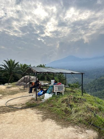
When you see the trig station, you'll know you've reached the peak of Bukit Senaling!
Even though the hike up Bukit Senaling is challenging, the gorgeous panoramic scenery of Kuala Pilah that awaits you at its peak makes it well worth the hike.
If you wish to see the breathtaking views of carpet clouds from the peak of Bukit Senaling, you should start hiking around 6:00 AM.
Entry Fee: RM15
Hiking Time: 2 hours 15 minutes
Trail Distance: 5.5km
Elevation Gain: 336m
Opening Hours: 24 hours, daily
Address: Bukit Senaling, 72000, Kuala Pilah, Negeri Sembilan

7. Bukit Baginda, Kampung Majau
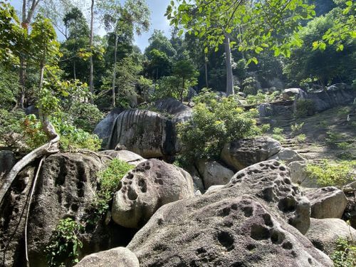
If you're planning to hike Bukit Baginda, you don't want to miss out on seeing the main attraction - the famous 40-metre-wide wave rock!
You will begin your journey by hiking through a river bed that leads you through rock-forming caves. Although the journey through the caves isn't long, everyone in your hiking group should have a headlamp to help navigate through the darkness better.
There are many rope sections during this hike, so having a pair of gloves will help prevent calluses and provide a firmer grip! Leeches and mosquitoes have been sighted around Bukit Baginda as well, so don't forget your bug repellent and eucalyptus spray to keep them away.
The trail at Bukit Baginda is rather well-marked with checkpoints, so you will know you are on the right track.

When you reach the peak, you won't see much scenery, only a couple of banners. After all, the main attraction is the wave rock, which is about 2 to 3 minutes away from the peak.
After descending from Bukit Baginda, you can take a 10-minute drive to Taman Eko Rimba Jeram Tengkek to see the waterfall and use the public toilets there.
Entry Fee: RM8 = RM5 (permit) + RM3 (entrance fee)
Hiking Time: 3 hours
Trail Distance: 3.9km
Elevation Gain: 348m
Opening Hours: 24 hours, daily
Address: Kampung Majau, 72200 Batu Kikir, Negeri Sembilan

8. Bukit Putus - Gunung Angsi Trail
If you're looking for a challenge, check out Bukit Putus located just 18 minutes from Tanjong Ipoh! Bukit Putus trail leads you to Gunung Angsi, Negeri Sembilan's third highest peak - which is also a highly challenging one.
To prepare for the hike, I recommend packing your hiking stick and equipping high quality hiking shoes that have been worn in (you don't want a rigid pair!). Don't forget to bring some snacks and up to 2L of water in the Montigo Ace Bottle Massive to stay nourished throughout your hike. As there are no toilets at the summit, I advise using the restroom before you start your journey.
Your journey begins through sets of cemented and metal staircases, followed by a steep incline until you reach flat ground. This is where you can catch your breath before continuing onwards.
Ropes are available along the way to help you ascend the steeper grounds, with markers on tree trunks that line the way to keep you on the right track. There is also a swampy area with planks and stumps that serve as a walkway to help you avoid getting stuck in the mud.
There is a scenic spot along the way, just before you arrive at the summit. Here's where you want to make sure your phone and power bank are fully charged for stunning photographs!
Once you reach the top of the mountain, you can enjoy a picnic and rest on flat ground before descending Gunung Angsi.
Some hikers enjoy an extended challenge by descending through the Ulu Bendul hiking trail. That said, it's an extensive trail that's much tougher than Bukit Putus. You will also need to cross rivers here, so be sure the weather is bright and sunny if you want to leave via the Ulu Bendul trail.
Lastly, always check whether Ulu Bendul is restricted for the day as the authorities typically close it during rainy periods to prevent accidents from the rising river.
Entry Fee: RM5
Hiking Time: 4 hours
Trail Distance: 9.5km
Elevation Gain: 606m
Opening Hours: 24 hours, daily
Address: Jalan Kuala Pilah, Seremban, Negeri Sembilan

9. Tanjung Tuan Recreational Forest
Tanjung Tuan Recreational Forest is a nature preserve in Melaka with some parts of the forest extending into Negeri Sembilan. It's the perfect place for birdwatchers who can catch the spring migration of raptors between February to April.
This is tied to Tanjung Tuan's annual birdwatching event called the Raptor Watch, which is usually held in March. You'll get to see raptors such as the Chinese Goshawk, Greater Spotted Eagle, and White-Bellied Sea-Eagle. How cool is that?
And while you're here don't forget to check out the Cape Rachado Lighthouse, which is believed to be the oldest lighthouse in Malaysia. Entry may be restricted, but it's still worth a visit.
One of the reasons this place is so popular is there are many hiking trails for you to explore, ranging from easy to moderate in difficulty.
One of the most popular hiking trails here is the Bukit Batu Putih trail, which takes you less than 90 minutes to climb. There are two ways to climb Bukit Batu Putih which starts on the right-hand trail before the lighthouse. This takes you through the jungle before a short climb to the top. If you're not looking for a long hike to the top, this is the hiking trail for you!
The other way is to go via the Monkey Bay trail. You will arrive at the beach after trekking through the jungle, followed by a steep walk to Bukit Batu Putih. This route is harder and lengthier compared to the first one. If you do decide to attempt the Monkey Bay trail, start by checking online for the high tide times for the day as it may be unsafe to traverse the beach route during high tide.
What makes Bukit Batu Putih so special is the stunning views of the rainforests and Straits of Malacca you get from the quartz ridge. It gets pretty hot as there is no shade at the summit, so hike early to avoid the midday heat.
Entry Fee: RM1
Hiking Time: Up to 1 hour 41 minutes
Trail Distance: Up to 5.6km (longest trail)
Elevation Gain: 194m
Opening Hours: 8:00 AM to 6:00 PM, daily
Address: Jalan Pantai, Tanjung Tuan, 71050 Melaka

10. Bukit Taisho, Bahau
Bukit Taisho is a popular hiking spot found in Bahau within Negeri Sembilan. It will take half an hour to 45 minutes to reach the summit, but it's a relatively easy hike up the hill, so it's suitable for beginners! In fact, many elderly locals hike Bukit Taisho often. And if you're lucky, you may encounter refreshment stalls at the top of the hill. You should still bring some snacks and drinks in case they aren't there when you are.

There are a few entrances to Bukit Taisho. If you end up at the entrance where the Muslim cemetery is, please keep in mind this is not a popular route as most people usually use the entrance at Jalan Meranti 2.
Along the way, you will see oil palm estates as you climb the hill. As there is no shade at most of the trail, it may be quite hot, especially when you're descending. But the good news is there are no leeches here! As it becomes steeper, be mindful of where you're stepping because the gravel and rocks can be quite loose.
Many people like hiking Bukit Taisho after it rains overnight to see the "awan karpet", otherwise known as the carpet of clouds. The best time to see these lovely clouds is to reach the top of Bukit Taisho before 7:00 AM.
Entry Fee: Free
Hiking Time: 1 hour 30 minutes
Trail Distance: 2.9km
Elevation Gain: 216m
Opening Hours: 24 hours, daily
Address: 72100 Bahau, Negeri Sembilan

11. Bukit Sikai, Seri Menanti
Bukit Sikai is a lesser-known trail located at Seri Menanti that is easy to moderately challenging for hiking. It'll take less than half an hour to reach the top.
However, the trail can be pretty sandy with many holes on the way up! Thus, you should wear hiking shoes with grips and be alert about where you're stepping.
You will love the scenery at the top of Bukit Sikai. It's a beautiful place to see the sunrise and take photos of the panoramic views. There is also an area with chairs and tables for hikers to rest at the top of the hill. If you're lucky, you'll see the famous "awan karpet", also known as carpet clouds! To catch a glimpse of these beautiful clouds, arrive at the peak before 7:00 AM.
Keep in mind that Bukit Sikai is located on private land, along with a building for collecting bird nests and a small pond. Hence, be nice and not litter the place! There may be limited parking in this area, so you should start your hike early.
Entry Fee: Free
Hiking Time: Less than 50 minutes
Trail Distance: 1.9km
Elevation Gain: 106m
Opening Hours: 24 hours, daily
Address: Bukit Sikai, 71550, Negeri Sembilan