


Hiking Pahang: Top 11 Trails For A Scenic Adventure
Conquered the hiking trails of Selangor and Kuala Lumpur? We've got a new challenge for you.
Fret not, Pahang's lovely hiking trails are what you have been seeking. After all, Pahang is blessed with magnificent mountains like the popular Bukit Fraser, lush rainforests, and the now world renowned Teluk Cempedak beach (Jujutsu Kaisen fans, I'm watching you!), which will ignite your passion to seek new adventures!
From rugged trails to crossing the rivers that will lead you to the peaks with magnificent views, Pahang is one of the best places to hike in Malaysia.
We've compiled a list of some of the best hiking trails for you to explore in Pahang. So all you need to do is pack your hiking essentials and select the hiking trails that pique your interest!
11 Scenic Hiking Trails To Explore In Pahang (Including Trails That Promise A Tough Hike For The Veteran Hikers Among Us!)
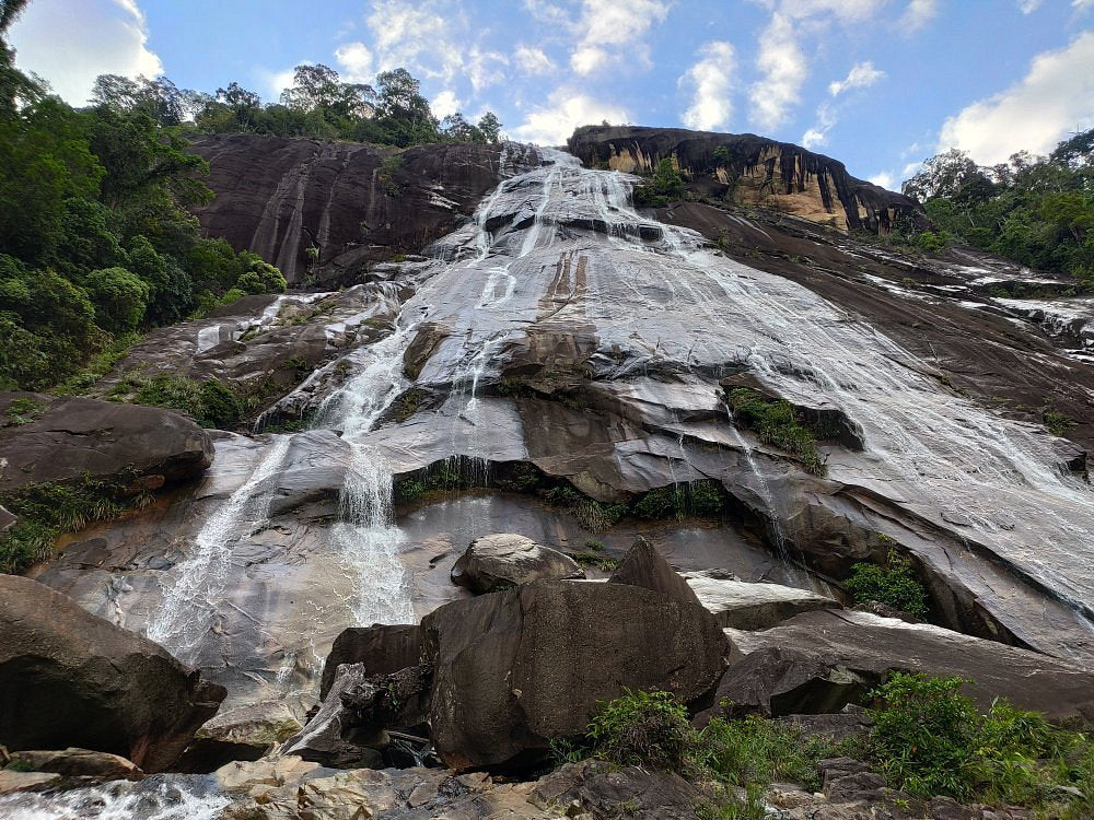
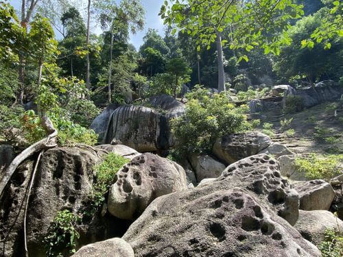
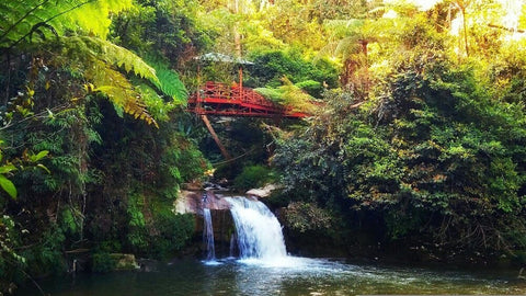
1. Parit Falls @ Tanah Rata
If you're looking for a place to hike and camp, Parit Falls is just the place for you. You will start hiking from Trail 5, moving on to Trail 6, before finishing at Trail 4.
However, if you are short on time, I'd recommend opting only for Trail 4 which leads you straight to the waterfall. A favourite photo that people love to take here is to capture the scenery of the quaint bridge above the waterfall.
The hike through the forest is an excellent workout that also showcases the beauty of Cameron Highlands. If you're new to hiking in this area, do download and use the Maps.me app for an easier time navigating through the hiking trails while ensuring that you're on the right track.
However, keep in mind that you will need to pay a permit of RM10 at Cameron Highlands District Forestry to access Trail 5.
For those interested in camping, Parit Falls Campsite has a total of 18 campsites available, starting from RM100 per night. The campsite includes barbecue grills, sinks, and bathrooms with water heaters.
If you do camp or spend a night or two in Cameron Highlands, don't forget to check out the local specialty dish - Strawberry Nasi Lemak at Kampung Taman Sedia. There may be some waiting involved especially during the busy season but it will be well worth it!
Entry Fee: RM10 for a permit
Hiking Time: 3 hours
Trail Distance: 5.8km
Elevation Gain: 280m
Opening Hours: 8:00 AM to 6:00 PM, daily
Address: Tanah Rata, 39000 Tanah Rata, Pahang
2. Gunung Rajah @ Bentong
For thrill-seekers looking for a new adventure in Malaysia, why not consider Gunung Rajah?
Due to its distance and navigational difficulty, Gunung Rajah is considered an extremely tough hike that is recommended for expert hikers seeking a new challenge.
While it is possible to do a day trip to reach the peak, hikers usually prefer to opt for a 2-day-1-night trip for Gunung Rajah. You will have enough rest, and you don't have to rush through the day to hike to the peak.
There are two places for hikers to camp overnight here - Lata Naning and Kem Batu Hijau. Before you begin hiking, remember to apply for your permit of RM10 at least 14 days in advance with the Forestry Department.

Your hiking journey begins at the parking lot located near the Chamang Waterfall. Some hikers begin around 7:00 AM or even earlier. If you plan to start before sunrise, don't forget to wear your headlamp to keep your hands free while climbing.
Along the way, there are several water points for you to refill your bottles. As this is a pretty challenging hike, make sure you bring your hiking stick, snacks, and 2L of water in the Montigo Ace Bottle Massive.
The trail becomes tougher after the last water point. But you don't have to worry because some areas provide ropes to help you hike to the peak. Although the climb is challenging, the view at the peak is super worth it!
Throughout your hiking experience at Gunung Rajah, be prepared to cross a few rivers. Your shoes may get wet at some point, so remember to bring a change of socks.
Entry Fee: RM10 for a permit
Hiking Time: 13 to 15 hours (day trip) or 2 days and 1 night (camping at Lata Naning campsite)
Trail Distance: 25.6km
Elevation Gain: 1,872m
Opening Hours: 24 hours, daily
Address: Gunung Rajah, 44000, Pahang

3. Pine Tree Trail @ Bukit Fraser
Pine Tree Trail is Bukit Fraser's most challenging hill, which is perfect for those looking to take their hiking experience to the next level. As this is considered a difficult trail, remember to put on a good pair of hiking shoes with anti-slip soles to ease your climb.
Many people consider this place like a rollercoaster, as there are plenty of uphill and downhill moments. For instance, you'll start the trail by walking downhill for some time before eventually going uphill.
Just before reaching the peak, you will arrive at a steep rocky slope that leads you to Pine Tree Hill. This is where your gloves will come in handy, as they'll provide a firmer grip on the rope as you ascend this rocky obstacle. It might look hard to climb, but trust me, you've got this!
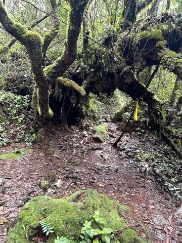
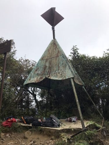
The peak of Pine Tree Hill offers a great view of Titiwangsa. If you continue to hike for another half an hour through the mossy forest to Twin Peaks, you get to check out the state border line which shows that Pahang is on the right side and Selangor is on the left side.
There are plenty of interesting plants along Pine Tree Trail. Watch out for the ferns on the trees, pitcher plants, orchids, and of course, the "cave" made from tree roots!
If you're starting your hike very early or rather late in the day, consider bringing a headlamp to help ease your hike down the hill.
Entry Fee: RM10 for a permit
Hiking Time: 7 hours
Trail Distance: 10.1km
Elevation Gain: 693m
Opening Hours: 24 hours, daily
Address: 49000 Bukit Fraser, Pahang
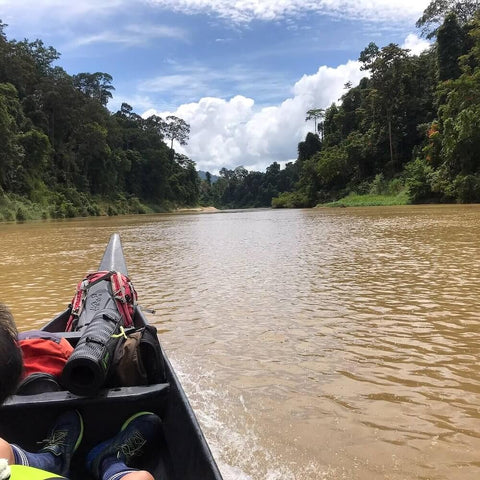
4. Taman Negara
At over 130 million years old, Taman Negara is one of the oldest rainforests in the world. So, if you're planning to hike a few areas in Pahang, you shouldn't miss out on Taman Negara.
There are many trekking activities available at Taman Negara. With the exception of the Canopy Walkway, all other trekking activities range from day trips to multi-day exploration that requires a guided tour.
During the guided tour, the guides will assist you throughout the trekking while sharing their knowledge about the rainforest with you as you navigate through hiking trails that alternate between elevated walks and natural dirt paths.
Taman Negara is home to many species of flora and fauna, so it will be a very fascinating experience that you do not want to miss out on. You might see tapir, hornbills, deer, and many more! Some hikers may even encounter the odd snake slithering about the track, but the local guides are incredibly sharp and will point it out before you even get close to it (just so you are aware!).

If you decide to go for the cave exploration expedition, you may come across other species such as bats, snakes, and different types of insects.
Remember to wear a good pair of hiking shoes to help ease your climb. Don't leave behind your bug-repellent and anti-leech socks, because leeches are rampant on damp trails!
Address: 27000 Kuala Tahan, Pahang
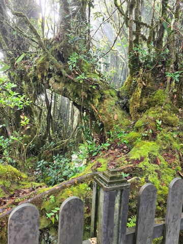
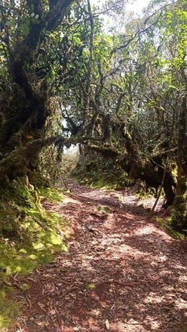
5. Mossy Forest @ Cameron Highlands
If you're a group of travellers planning a weekend getaway in Cameron Highlands, you should definitely add the Mossy Forest into your itinerary. However, this place isn't open all year round. It is closed during the rainy season, which is usually from November to January.
The Mossy Forest is a beautiful and mysterious nature preserve where moss blankets the trees and ground for as far as you can see. The best part is how it's a relatively easy boardwalk, making it perfect for beginners. You don't need to worry about getting lost as all you have to do is stay on track and admire the beauty of this mysterious place.

You will come across an observation tower in the middle of the trail that offers fine views of the cloud carpet and surrounding hills.
As Mossy Forest Trail is at high elevations of Cameron Highlands, it can become rather chilly. I'd recommend wearing a few layers when traversing this area.
To get to Mossy Forest Trail, the road uphill is rather narrow and muddy, making it rather challenging to drive. Therefore you aren't allowed to drive up there on your own. You will have to rent a 4-wheel drive or jeep for about RM20 to RM30 per person.
Entry Fee: RM10 for locals, RM30 for foreigners
Hiking Time: 1 hour
Elevation Gain: Up to 2,000m above sea level
Opening Hours: 9:00 AM to 4:00 PM, daily
Address: Gunung Brinchang, Brinchang, 39000 Brinchang, Pahang
6. Gunung Brinchang @ Cameron Highlands
Gunung Brinchang is the Cameron Highlands' second-highest mountain. Hikers used to be able to go on top of the observation tower at the peak, where you can see areas of Pahang and Perak. However, the peak is closed off to the public currently.
While the Trail 1 route is not available anymore, there is another new route that you can use to hike Gunung Brinchang. Lots of hikers have utilised the Maps.me app to help them navigate the route.
The entrance to the new trail is near the town of Brinchang. It may be slightly tricky to find. Be on the lookout for an orange sign that says "Gunung Brinchang Barat" with some kind of mini roof to the right, and you'll know you are at the right place.
Throughout the trail, you will see yellow markers, which you can just follow to stay on track. Some of these markers may end up somewhere in a bush, so be on the lookout for those.
Overall, the steep trail is rather muddy and slippery, so wear your best hiking shoes and bring your hiking poles to help ease your climb.
Towards the end of the trail, you will exit at Mossy Forest. As you won't find taxis up there, you might need to organise a 4-wheel drive in advance or walk down the hill to reach the tea farm.
It is a rather long walk from the tea farm back to Brinchang, which might take at least 2 hours. You might want to consider arranging transport ahead of time, or you can walk (again!) back to town.
Entry Fee: RM10 for a permit
Hiking Time: 1 hour 30 minutes
Trail Distance: 3.5km
Elevation Gain: 414m
Opening Hours: 8:00 AM to 6:00 PM, daily
Address: Jalan TM Gunung Brinchang, 39000 Brinchang, Pahang

7. Mount Jasar via Tan’s Camellia Garden @ Cameron Tea House, Cameron Highlands
Mount Jasar is a great way to get your workout in while admiring the scenic views of your surroundings. From the mossy forest to the sweeping views of the tea plantation, you're in for a treat!
You can park near Oly's Apartment before heading to Tan's Camellia Garden, where the trail begins. Once you've gone past the iron gate, you will see the trail on your left.
The trail may be rather slippery and muddy, so get your hiking poles ready! Some parts of the trail are pretty overgrown, which means mosquitoes and bugs. You might want to consider wearing long-sleeved attire and spray bug repellent to fend off those little buggers.
Eventually, you will arrive at a clearing with an electric tower. But this isn't the peak of Mount Jasar. You will need to walk up a slope till you reach another small clearing that shows the borders of Perak and Pahang.
You will continue your journey by hiking down the edge of the road back to the Cameron Tea House. Be wary as there may be many cars on the road. Some hikers choose to hitchhike or get a taxi down the road, as there isn't much to see on this part of the journey.
Hiking Time: 4 hours
Trail Distance: 11.1km
Elevation Gain: 574m
Address: 39000 Tanah Rata, Pahang

8. Bukit Raka @ Bentong
Bukit Raka has plenty to offer here. A challenging hike to the peak, gorgeous carpet clouds (or awan karpet), and a stunning view of Pahang on a clear day. So remember to wear your most comfortable hiking shoes for the adventure of a lifetime!
There are two trails at Bukit Raka - Trail A and Trail B. At Trail A, you will ascend via steep rocky areas that require excellent fitness. The steep rocky areas can be dangerous, especially during rainy days, even with thick and sturdy ropes. We would not recommend Trail A for those who are new to hiking.
If you're planning to pass through Trail A, be sure to pack your hiking gloves, which will come in handy when you're about to overcome the rocky obstacles. It's best if you have a safety helmet too when you're ascending the rocks.
Also, it's best not to crowd at the bottom of the rocky obstacle, in case any rocks roll down from the top.
On the other hand, Trail B is less challenging, as there are no rocks to climb down from. This makes Trail B much safer and relaxing when you leave Bukit Raka.
To experience the best of both worlds, many hikers like to hike to the peak via Trail A and prefer coming down via Trail B.
The reason why hikers don't do it the other way around is because it is more dangerous to descend the steep rocky areas unless you're extremely experienced with rock climbing.
Once you've reached the peak, you will feel your exhaustion wash away. You will have a superb view of Bentong and even spot Genting Highland on a clear day.
Entry Fee: RM10 for a permit
Hiking Time: 4 hours
Trail Distance: 4.3km
Elevation Gain: 438m
Address: 28700 Bentong, Pahang

9. Tasik Hijau @ Bukit Ibam
Tasik Hijau (which means Green Lake) is a short hike away from Tasik Biru (which means Blue Lake). As it is not a difficult or long hike, this is perfect for anyone who wishes to lay their eyes on this unique lake.
Tasik Hijau is believed to be a mixture of minerals that causes the water to have a unique green colour. As it is with most of the lakes in Malaysia, this lake is not strictly not for swimming, especially any lake that is associated with mining quarries.
Entry Fee: Free
Opening Hours: 24 hours
Address: 26700 Muadzam Shah, Pahang
10. Gunung Nuang via Janda Baik
Although Gunung Nuang is located in Hulu Langat, Selangor, this mountain is on the border between Pahang and Selangor. Hence, some might even consider this mountain to be part of Pahang.
Not only can you hike from Selangor, but you can also hike via Janda Baik, Pahang.
The good news is the hike up Gunung Nuang via Janda Baik is slightly easier compared to hiking via Selangor.
However, it is still a challenge to ascend Gunung Nuang via Janda Baik. So it's best to stay prepared with your hiking sticks, anti-leech socks (they are everywhere over there!), and your trusty Montigo Ace Bottle Massive that stores up to 2L of water.
If you're planning to hike before sunrise, don't forget your headlamp in case you need your hands to stabilise yourself while climbing.
You will pass by some farms and a rubber tree plantation before you reach the forest area. Eventually, you will need to cross a river by the Chemperoh waterfall. Also, from here onwards, you will very likely encounter leeches, whether it's on the ground or in the water.
Along the way, there are lots of interesting plants you will see, such as wild orchids, ginger, berries, pitcher plants, and more.
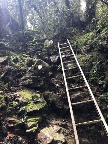
There is a flat clearing called Pematang where you can catch your breath for a while before continuing to the peak. While it's pretty steep, there are ropes to assist your climb to the peak. After one final climb of a ladder, you will reach the peak!
It is best to avoid this area during the rainy season, as the water can get pretty treacherous while you try to cross the river.
Entry Fee: RM10 for a permit and RM7 for parking
Hiking Time: 5 hours 34 minutes
Trail Distance: 11.9km
Elevation Gain: 989m
Opening Hours: 24 hours
Address: 43100, Selangor
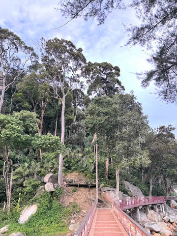
11. Teluk Cempedak Beach - Bukit Pelindung Trail @ Kuantan
If you're in Kuantan, you don't want to miss out on hiking to Teluk Cempedak Beach! The Teluk Cempedak - Bukit Pelindung Trail promises a moderately challenging hike while serving as a rather popular spot during the weekends, so you may encounter many hikers even in the early hours of the morning.
After you exit the trail, do make some time to enjoy Teluk Cempedak's beautiful scenery enjoying food to nourish yourself after hiking from one of the many food and drink stalls that line the coast. You can also rent a beach chair and umbrella to relax on the beach.
Another thing to note, the beach is pretty popular with the locals and travelers alike. So be prepared to see flocks of local families and even tourists during the weekends!
Entry Fee: Free
Hiking Time: 2 hours 33 minutes
Trail Distance: 6.6km
Elevation Gain: 399m
Opening Hours: 24 hours, daily
Address: 11459, Jalan Pelindung 2, Pelindung Heights, 25250 Kuantan, Pahang