


Hiking Kedah 101: A Discovery Of Scenic Trails, Mountains, And Waterfalls In The "Rice Bowl Of Malaysia"
Enter Kedah, the "Rice Bowl of Malaysia" which is renowned as such due to its vast paddy fields that account for approximately half of Malaysia's total rice harvest and output. It is also home to the beautiful island of Langkawi, loved by locals and tourists for its natural landscapes, vacation-vibes, and fun activities both on land and sea.
However, did you know that Kedah is also home to many spectacular hiking trails and lovely waterfalls that are not quite known to the public? Not only does it mean that you'll encounter fewer crowds around, but it also means relatively untouched stretches of nature, clean fresh air, and if you're lucky, possibly having the trails and waterfalls all to yourself and your hiking companions!
But wait, we most certainly can't forget the best part of going hiking in Kedah. After spending the morning or evening hiking the hills and mountains Kedah, you're bound to have a hungry belly that's waiting to be filled with Kedah's famous Laksa Kedah or Gulai Temenung!
Do these sound good to you? If so, lace up your hiking shoes, pack your hiking essentials, and round up your hiking companions because we're going to check out the hiking trails you can trek through in Kedah!
11 Breathtaking Hiking Trails In Kedah To Tick Off For Your Next Adventure In Northwestern Malaysia

1. Bukit Hash aka Bukit H (Trail Head Starts From Taman Semarak)
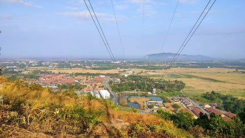
One of Kedah's most popular hiking spots is Bukit Hash, also known as Bukit H. But did you know that it is also known as Bukit Semarak because it's found in Taman Semarak?
Bukit Hash's hiking trail is a moderately challenging route with a trail head that begins at Taman Semarak. Think of this particular hiking trail as a scenic one because you will be treated to lovely views of the surrounding greenery along with a glimpse of the fruit farm nearby.
Even though the overall height of Bukit H isn't great, it does have steep climbs and the occasional slippery trails. So I'd recommend bringing your hiking stick and wearing proper hiking shoes for better stability instead of your regular pair of trail runners.
When you reach the top of Bukit H, head on to the viewpoint for a stunning view of the surrounding. It's quite spacious at the top of the hill so you can take a breather here before descending.
The trek also connects to Bukit Haji Yusof, which is home to a famous weekend-only food stall called Pondok Sarapan, which means Breakfast Hut in English.
Hiking Time: Approximately 1 hour 13 minutes
Trail Distance: 3.2km
Elevation Gain: 188m
Opening Hours: 24 hours, daily
Address: Taman Semarak, 08000 Sungai Petani, Kedah, Malaysia

2. Mount Jerai and Air Terjun Alor Naga
Looking for a challenge? Then Mount Jerai, which is also famously known as Kedah Peak, is for you. It is one of the highest peaks in Kedah that stands tall at the height of approximately 1,217m. Which is why those who have scaled to the peak of Penang Hill will be able to spot the silhouette of Mount Jerai.
Mount Jerai's Merbok trail head lies at the parking lot of the Lembah Bujang Archaeological Museum. The trail to the summit is rather steep and rocky, which also becomes very muddy and slippery after rain, so you'll want to wear proper hiking shoes that provide stability in wet terrain and bring insect repellent to ward off mosquitoes.
You will also be "attacked" by leeches throughout your hike. Remember to wear anti-leech socks and apply some eucalyptus essential oil on your legs to keep them away! That said, Mount Jerai is also home to Malaysia's native plant-life such as the pitcher plant.
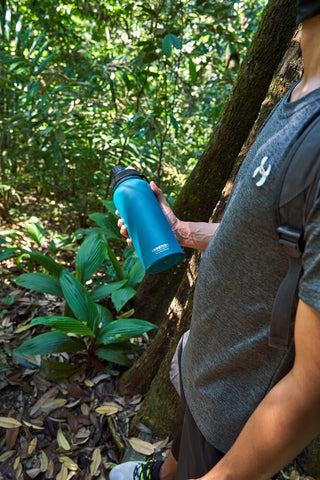
The mountains are also known to be slightly chilly, so you'll want to wear a long-sleeved top or a jacket will help you stay warm, and bring a bottle of hot coffee or Milo in the Montigo Ace Bottle to keep your energy levels up along the hike.
If you want, you can even spend the night at the hill resort on the summit of Mount Jerai. The summit offers a lovely view of Kedah's vast paddy fields and even sightings of Penang Island on clear days. Good thing you can drive up the hill or hire a van to take you to the resort, so you don't have to carry your luggage while hiking!
Fun Fact: Some hikers even opt to drive up to the resort and begin their hike there at midpoint for an easier and shorter hiking session.
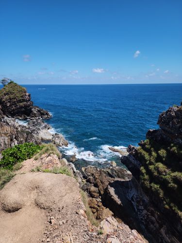
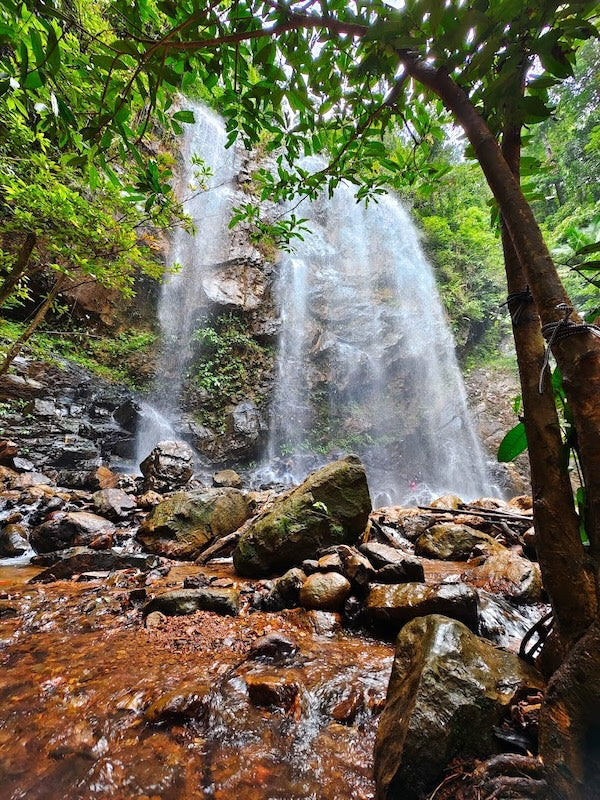
Mount Jerai is also home to a waterfall called Air Terjun Alor Naga. It has an interesting local fable where the waterfall is believed to have been the dwelling place of a dragon who bathed in the cooling waters. At a mere 30-minute walk from the resort, I'd say it's definitely worth a visit!
But if you're not staying at the resort nor starting your hike from it, the Tangga Kenari route is an alternative trek to the waterfall which takes approximately 1 - 2 hours.
Hiking Time: Approximately 5 to 6 hours
Trail Distance: 15.3km
Elevation Gain: 1,184m
Opening Hours: 24 hours, daily
Address: Mount Jerai, 08300 Yan, Kedah, Malaysia
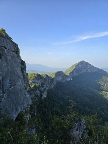
3. Gunung Keriang
Located in Alor Setar, Gunung Keriang is a natural stunning landmark of a limestone hill that resembles the shape of an elephant. This natural formation is estimated to be about 250 million years old!
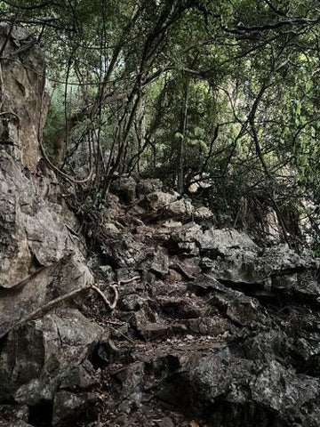
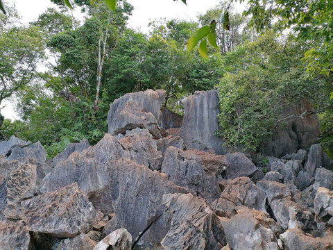
Gunung Keriang's hiking trail is considered to be moderately challenging. The trail starts behind a Muslim cemetery. Although it consists mostly of stairs, the steps are very steep and narrow.
Even though there are rail guards and ropes around to assist your ascent, it's definitely a safer choice to take your time climbing, especially since some parts can be at an incline of up to 75-degrees! Keep an eye out for spray-painted red arrows to know you're on the right track.
Most of the hiking route is made of rock with lots of jagged and sharp stones at higher ground. Hence, wearing proper hiking shoes to protect your feet from injury is a must, along with wearing long pants to prevent random cuts or scrapes from the jagged stones.
On the way to the peak, you will come across a cave with a perfectly round entrance that contains ten different types of rocks and beautiful calcite crystals. If you plan to explore the cave, remember to bring a flashlight or headlamp, so you can look around without depleting your phone battery (unless you've packed a powerbank with you).
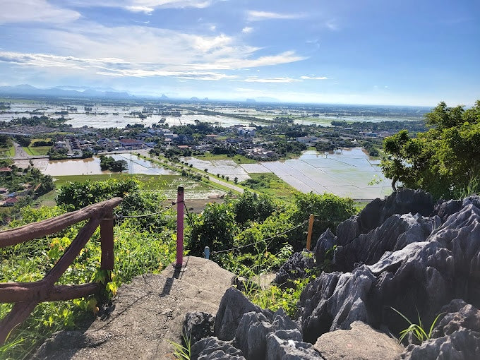
The breathtaking views of the paddy fields from the peak are what attracts hikers to take the challenge to scale Gunung Keriang. Even if you do not reach the peak, several spots along the trail offer a stunning view of the paddy fields right up to the Straits of Malacca.
Entry Fee: Free
Hiking Time: Up to 2 hours
Trail Distance: Up to 8km
Elevation Gain: 190m
Opening Hours: 24 hours, daily
Address: Kampung Gunung Hulu, Alor Setar, Kedah, Malaysia

4. Bukit Perangin and Air Terjun Bukit Perangin
Those who wish to escape the hustle and bustle of the city will love this trail! But before we go on, take note that the hill is part of Hutan Simpan Bukit Perangin so you will need a permit from the Jabatan Hutan Kedah to hike here.
Bukit Perangin's hiking trail will take you through dirt paths and jungle treks before you arrive at the waterfall in a couple of hours. As you will also cross several streams, remember to bring extra socks and a pair of shoes to change at the end of the hike if you're not too keen on continuing the hike with soggy shoes.
When you reach the waterfall, you'll be amazed at how beautiful and refreshing the water is. You will also get to relax by having a picnic at the cascading waterfall. However, hikers have reported the occasional leech sightings around the waterfall, so watch where you step! And remember, always take your rubbish home with you so we can preserve this hidden gem's pristine, natural beauty.
Hiking Time: 1 hour 45 minutes
Trail Distance: 5.8km
Elevation Gain: 205m
Opening Hours: 24 hours, daily
Address: 06010 Changlun, Kedah, Malaysia
5. Gunung Baling
Gunung Baling is one of Kedah's most popular hiking spots. The hiking trail here is a moderately challenging one which makes it perfect for beginners who wish to build their hiking stamina.
You need to obtain a permit from Majlis Daerah Baling at least three weeks in advance to hike Gunung Baling. Every group of up to 10 hikers must have a guide to lead you up the hill.
The trail contains well-marked signs, so you will know you are on the right track. There are ropes and handrails to provide support as you ascend the steeper parts of the hill. Nevertheless, the trail becomes quite slippery during the rainy season so it's best to bring your trusty hiking stick to reduce the risk of falling.
As you come to the end of the jungle trail, you will need to crawl under some rocks to the ridge. Once you've passed this area, you will climb among sharp limestone rocks. Thus, thick cotton hiking gloves are strongly recommended to prevent you from getting cuts when you hold onto the rocks for support.
But I promise that the 360-degree view is well worth the challenge and sweat you will face for those couple of hours! Yyou can see Thailand to the east and Penang Island to the west on clear days at the peak. Gunung Pulai is also within sight, which could be your next hiking destination if you're an adventurous and experienced hiker.
Entry Fee: RM10 (Locals); RM30 (Foreigners)
Guide Fee: RM100 to RM150 (Up to Groups of 10)
Hiking Time: 1 hour 30 minutes (1 way)
Trail Distance: 3.2km
Elevation Gain: 432m
Opening Hours: 8:00am to 2:00pm, Saturdays to Thursdays (must start hiking by 10:00am)
Address: Baling, 09100 Baling, Kedah, Malaysia

6. Gunung Pulai
Experienced hikers looking for a challenging hike simply must attempt Gunung Pulai, which is made up of approximately 80% rocks. It's an incredibly tough climb which requires a lot of strength and willpower to reach the top. Some even say the descent down the mountain is the toughest part.
That's why you have to obtain a permit from Baling's firefighting department up to a week in advance before you can even begin your hike.
But with all that, Gunung Pulai is popular amongst the veterans for the stunning panoramic view at its peak. Many hikers also start hiking as early as 3.30am to catch the sunrise. To be on the safe side, it's best to hire a guide to lead the way, especially if you are hiking in the dark. A headlamp is a must since you will use your arms often to support your climb.
When you reach the peak of the rocky mountain, all your fatigue will fade away as you are greeted by the gorgeous scenery of Kedah as a whole.
Throughout the hike, you will encounter sharp and slippery rocks, some even at an incline of up to 70°. So, wearing a pair of thick cotton gloves will help you maintain your grip, while proper lightweight hiking shoes with ample threads will reduce your chances of slipping on the rocks with more mobility.
Hiking Time: 3 to 4 hours
Trail Distance: 2.6km
Elevation Gain: 535m
Opening Hours: 24 hours, daily
Address: Kampung Teluk Tak Patah, Baling, Kedah
7. Bukit Kodiang
Bukit Kodiang, also known as Bukit Mok Cun, is a short but gruelling trail for hikers seeking a challenge.
Bukit Kodiang becomes steeper and more challenging the higher you climb. You may even find yourself climbing up a ladder at 90°. Which is why lightweight hiking shoes are highly recommended here to stabilise yourself throughout the hike. The trail is also littered with sharp rocks, challenging rope climbs, and ladder climbs. So cotton gloves are a must here to prevent injury on your hands.
But the end result of the tough journey up this rocky hill will be incredibly worth it. You will be rewarded with panoramic views of the paddy fields, all perfect for taking Insta-worthy pictures (not forgetting bragging rights!).
Entry Fee: RM2 (parking)
Hiking Time: 30 - 60 minutes, depending on your stamina and strength
Trail Distance: 500m to 600m
Height: 140m
Address: Kampung Kandis, 06100, Kodiang, Kedah, Malaysia
8. Bukit Telipong
Known for its panoramic views at the top, Bukit Telipong is a favourite hiking spot among locals. To reach the car park, key in "Felda Batu Lapan, Changlun, Kedah" in your GPS, be it Google Maps or Waze.
Bukit Telipong's hiking trail starts by walking through the rubber plantation. With many mosquitoes in this area, remember to bring insect repellent to reduce unwanted mosquito bites. Some areas of the trail are rather steep with loose gravel, which can be dangerously slippery. Thus, opt for worn-in hiking shoes to ease your climb over your usual trail runners.
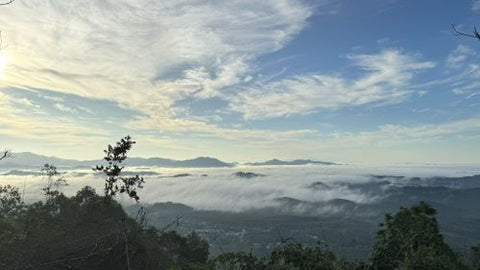
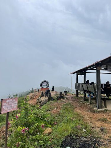
You'll know you're at the peak once you spot the cafe that serves breakfast from 7:00am to 12:00pm from Thursdays to Mondays. It's a relaxing, scenic place to hang out as you take in the sunrise and the views of Perlis, Alor Setar, and Thailand.
If there was a heavy thunderstorm the night before your hike, you may even be treated to rare sightings of the sea of clouds from the top of the hill! You can start hiking as early as 6:00am for a chance to see the sea of clouds.
Bonus Tip: On the weekends, some people prefer to hire a 4-wheel drive to take them to the top for breakfast then hike their way down Bukit Telipong right after.
Entry Fee: RM3 for parking
Hiking Time: 1 hour 44 minutes
Trail Distance: 4.5km
Elevation Gain: 270m
Opening Hours: 24 hours, daily
Address: Bukit Telipong Felda Batu Lapan, 06010, Bukit Kayu Hitam, Kedah, Malaysia
9. Bukit Laka @ Bukit Tok Dun
Bukit Tok Don is a uniquely positioned hill found right at the border between Kedah and Perlis. In fact, you can start hiking from Arau in Perlis or Bukit Kayu Hitam in Kedah.
The hike takes you through a rubber plantation and pebbled trails. As you get closer to the top, the trees start thinning out, and you will find yourself hiking through a bare trail. If you're looking for a more pleasant, leisurely hike, it's best to start your hike early in the morning for a cooler experience.
Bukit Tok Don's Kedah trailhead and Bukit Telipong are neighbouring hills. So, if you have crazy plans to conquer a few summits during the weekend, you'll find it convenient to climb these two on the same day.
Entry Fee: Free
Hiking Time: 1 hour 28 minutes
Trail Distance: 4.2km
Elevation Gain: 216m
Opening Hours: 24 hours, daily
Address: Unnamed Road, 02600, 02600 Arau, Perlis
10. Bukit Malau
Bukit Malau is perfect for beginners who want to train their hiking stamina. Surrounded by lush greenery, it is a lovely hike to the top. You may even come across some monkeys along the way.
Some areas have ropes to help your ascent across steeper areas. During the rainy season, the trail is quite slippery so wear proper shoes with strong grip and bring along your hiking stick just in case.
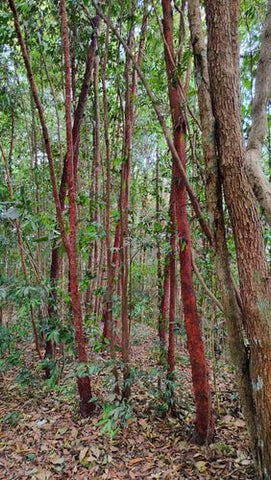
At the last checkpoint, there's a pretty area covered with red trees which is a nice spot to catch your breath and capture some scenic shots. Nevertheless, your fatigue will fade when finally get to the peak and embrace the spectacular panorama of Kedah's famous paddy fields.
Fun Fact: Did you know that "malau" is a cantonese word for "monkey" or "naughty child"? ;)
Entry Fee: Free
Hiking Time: 1 hour 16 minutes
Trail Distance: 3.1km
Elevation Gain: 211m
Opening Hours: 6:30 AM to 7:00 PM, daily
Address: Pekan Jitra, 06000 Jitra, Kedah, Malaysia

11. Bukit Bunga Raya
For any beginners looking for a short and manageable hike, Bukit Bunga Raya is just the right one for you. It's not very steep so you may even encounter local families enjoying a recreational day out on the trail here.
The summit offers you a bird's eye view of Kedah, which is also the other reason why this place is such a popular hiking spot amongst the local residents especially during sunrise and sunset. There is also a little hut you can rest in at the peak while soaking in the beautiful surroundings before you hike down the hill.
Do note that the hiking trail may become muddy and slippery during rainy months so suitable hiking shoes and your trusty hiking stick are a must. Besides, you may run into pesky mosquitoes throughout the hike so have your insect repellent ready to keep them at bay and away!
Entry Fee: Free
Hiking Time: 34 minutes
Trail Distance: 1.4km
Elevation Gain: 92m
Opening Hours: 24 hours, daily
Address: Sintok, 06010, Bukit Kayu Hitam, Kedah, Malaysia