


Hiking Terengganu: 11 Trails To Explore For A Real Adventure
When Terengganu comes to mind, you think of its cultural heritage, pristine white beaches, and strikingly blue waters. Not to mention its famous nasi dagang, nasi kerabu, keropok lekor (you simply must try the steamed one), and nekbat because how can we miss out on the local delights when we're in Malaysia!
But there is more to this northern state than meets the eye. Terengganu is full of trails hidden in dense rainforests and neighbouring hills with picturesque views awaiting your visit.
From trekking through Terengganu's lush jungles that are just teeming with flora and fauna to admiring stunning vistas from the summits, and not to mention sound baths in the forests which is a true stress-relieving activity to experience away from the hustle and bustle of the city. Whether you're a beginner or a seasoned hiker looking for a new challenge, Terengganu is home to hiking trails that suit everyone.
So grab your hiking essentials, call up your hiking friends, and get ready because we're going to hike the mountains and hills of Terengganu for a thrilling adventure unlike any other!
11 Spectacular Hills & Mountains To Explore While Hiking Terengganu For A Thrilling Experience

1. Bukit Singa
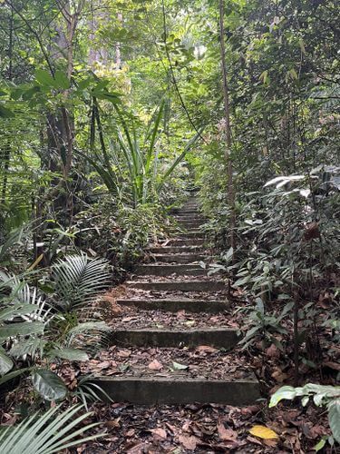
Bukit Singa is found on the far northern end of the Kuala Terengganu, so if you've planned a vacation on the lovely Pulau Kapas, this is one hill to explore along the way. Bukit Singa's name which directly translates to "Lion's Hill" in Malay was derived from its resemblance to a lion's head. But you can only see the resemblance when you take a look of the hill from the side instead of a close view from the peak.
The trail to the summit isn't a particularly long one, which makes it a fun and easy trail to add into your vacation itinerary that even beginner hikers can attempt.
To start your journey, you will be climbing a few flights of stairs at the beachside that takes you along the coastline. The moss-covered stairs have some narrow steps and footpaths that have eroded due to the ocean waves so here's a heads up to be cautious while walking through those areas.
It is best to attempt the hike up Bukit Singa during low tide so you don't have to venture through the high rocky areas. The water could reach your waist level in certain areas during high tide!
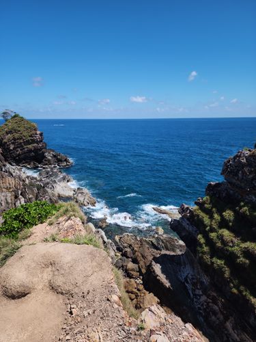
Throughout the hike, you'll be treated to lovely scenic views of Pulau Kapas which include the South China Sea. While the panoramic views of the South China Sea are truly stunning, it can get rather windy at the peak. So, take care steer clear of the edge.
Due to the sharp rocks on the terrain, proper hiking boots and gloves are highly recommended to protect your feet and hands from injury. Insect repellent will also be really helpful while hiking this route. As there most parts of the route tend to be exposed, sunscreen and a hat are a must to protect yourself against the harsh sunrays.
Those hiking Bukit Singa for the first time may find the route confusing as there is no clear path. Hence, you can consider hiring a guide or joining a tour group on the island at the Marang Jetty.
Bukit Singa's hidden gem would definitely be the Blue Lagoon. You'll be mesmerised by the natural beauty of the calm crystal clear waters shimmering under the sun. Not to mention the contrast created by the white sand and greenery that completes the beautiful scenery.
The lagoon is a tranquil place to relax at the water's edge and take many photos. However, the Blue Lagoon only comes to life during high tide and has many sharp rocks in the area.
Hiking Time: Up to 1 hour 15 minutes
Trail Distance: 3.9km
Elevation Gain: 89m
Opening Hours: 24 hours, daily
Address: Pulau Kapas, Kuala Terengganu, Terengganu

2. Bukit Keluang
For hikers who love admiring coastal sceneries, you will love hiking at Bukit Keluang which is located by the ocean. After parking your car at the parking lot by the beach, you will begin your hike by climbing a flight of stairs opposite the toilets en route to the dirt path.
While some areas are rather steep, there are ropes along the way to ease your journey. During the trek, you may spot wildlife such as monkeys, monitor lizards, and squirrels.
The hike may be challenging, but once you're at the top you'll be rewarded with a magnificent scenery of the South China Sea and surrounding islands.
One thing to keep in mind is how the viewpoints are located along the cliff top. Thus, handrails have been set up by the edge of the cliff for safety purposes as the ledges are crumbling away due to consistent exposure to the salty atmosphere. A large wooden shade is set up at the peak for you to sit and relax on the wooden benches so you can have a mini picnic to refresh yourself before descending.
The hill is suitable for beginners to build their stamina for strenuous hikes in the future. I'd recommend wearing proper hiking shoes over your standard trail runners or sneakers for better stability while hiking the steeper areas along the route even though it appears much like a casual hike.
The beach near Bukit Keluang is incredibly beautiful. It comes to life during the weekends when people come here for picnics and camping trips, and it's also the perfect place to take a break after hiking Bukit Keluang. If you walk along the wooden walkway on the rocks by the hillside, you can even check out the littoral caves during low tide.
Hiking Time: Up to 1 hour
Trail Distance: 2.3km
Elevation Gain: 143m
Opening Hours: 24 hours, daily
Address: Bukit Keluang Trailhead, 22200, Terengganu

3. Air Terjun Langsir Waterfall
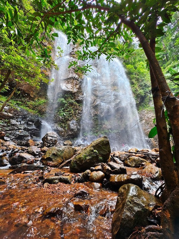
Did you know that Terengganu is home to the Chemerong Forest Reserve which houses the Air Terjun Langsir, Air Terjun Chemerong, and Gunung Berembun? In fact, many veteran hikers refer to the hiking trip for the three places as the CBL loop, which takes up to 3 days and 2 nights.
Air Terjun Langsir is an ideal place for watching the sunrise or admiring stars that are rarely seen in the city. Its cascade boasts several tiers with endless pools of crystal clear waters you can bathe and relax in. This particular waterfall is said to be one of Malaysia's most gorgeous waterfalls that you do not want to miss out on.
To hike at the CBL loop, you will need to register for a permit at RM5 per person and you can also opt to have a guide with you. You can check out Terengganu Forestry for more information.
Permit: RM5 per person
Height: 2,628 metres
Opening Hours: 7:00am to 6:00pm, daily
Address: 21700 Kuala Berang, Terengganu

4. Bukit Besar
Bukit Besar is a famous hiking spot in Kuala Terengganu, located opposite the neighbourhood Hiliran Recreation Park. It is the locals' favourite activity during the weekend to trek here. Thanks to its popularity, you'll also find stalls set up at the foot of the hill that offer refreshments and snacks.
The hike involves a trek through the jungle with some tricky parts involving rope-assisted climbs. But when you reach the peak, you'll be greeted by a spectacular view of the lush green jungle and ocean, making the challenge well worth it. But do note that the peak is rather barren with no shade, so you may want to slather on the sunscreen and don a hat to protect yourself against the sun.
Hiking Time: Up to 1 hour 30 minutes
Trail Distance: 3.5km
Elevation Gain: 193m
Opening Hours: 7:00am to 6:00pm, daily
Address: Jln TM Bukit Besar, Kuala Terengganu, Terengganu

5. Bukit Tok Salai
Located within a palm grove, Bukit Tok Salai is considered a moderately challenging route that is perfect for hikers who desire to improve their hiking skills and stamina.
Some areas of the trail are pretty wide, making it convenient for you to stop and catch your breath before continuing. The steeper regions can be quite slippery to navigate, especially when it rains. Hence, bringing your hiking stick will help reduce the strain on your knees and enjoy more stability as you trek through the trickier areas. There are also ropes along the route for you to use as extra support.
One really cool thing about hiking Bukit Tok Salai is that you'll have the chance to see a carpet of clouds at the peak early during early mornings. You will also enjoy panoramic vistas of the surrounding farms, valleys, and the lovely Sungai Nerus which makes you feel as though you aren't currently in Malaysia.
Another plus point is that the peak is covered with trees, so you won't feel much of the sweltering heat even if you begin hiking late in the morning.
Hiking Time: Up to 2 hours
Trail Distance: 3.1km
Elevation Gain: 186m
Opening Hours: 6:00am to 7:00pm, daily
Address: Bukit Tok Salai Sungai Nerus, 21200, Kuala Terengganu, Terengganu

6. Bukit Tok Gunung
For hikers seeking a challenging route, Bukit Tok Gunung is right up your alley. You will begin your journey by walking along the logging trail before going through the rainforest which is home to a diverse ecosystem.
The trail is rigorous, alternating between narrow pathways so you will find a hiking stick to be very helpful in providing you balance over slippery areas. Along the route, you might catch a glimpse of the stunning Air Terjun Olak Lintang as you hike through the lush rainforest. In fact, you can even see Tasik Kenyir before you reach the top, making Bukit Tok Gunung a favourite amongst explorers.

After going through four checkpoints, you'll arrive at the summit which has a flat and spacious place to relax and enjoy the stunning scenery. Remember to bring snacks to replenish your energy after the challenging hike and up to 2 litres of water in your trusty Ace Bottle Massive to stay refreshed and hydrated throughout your hike.
To ascend Bukit Tok Gunung, you will need to obtain a permit from the Terengganu Forestry Department and inform the Balai Polis Hulu Terengganu and MPKK Jenagor of your hiking itinerary.
Hiking Time: Up to 3 hours 30 minutes
Trail Distance: 6km
Elevation Gain: 540m
Opening Hours: 24 hours, daily
Address: 2WW4+G3, 21700 Kuala Berang, Terengganu

7. Bukit Jelutong
Bukit Jelutong is the perfect trail for hikers to build their stamina before moving on to intermediate trails. Some even use it to train for future climbs up Mount Kinabalu! That said, it is also a short but steep hike to the peak, making it suitable for a quick workout in the morning.
You will begin your journey on the white paved road before walking the rest of the way on the logging trail. However, be careful while navigating the logging trail as you may lose your balance on the fine sand that blankets the area. Thus, we recommend opting for proper hiking shoes and a hiking stick instead of your usual trail runners.
As there are no canopies of trees throughout the route and at the summit, it's best to start hiking as early as 6:45am to avoid the intense heat later.
Once at the top, you'll be rewarded with a 360-degree panoramic view of Terengganu. You can even buy drinks from the stalls and sit on one of the many benches as you soak in the beautiful surroundings. You might even spot the sea of clouds in the morning!
Hiking Time: 30 minutes (1 way)
Height: 200m above sea level
Address: Bukit Kepah, 21700 Kuala Berang, Terengganu

8. Bukit Maras
Bukit Maras is another moderately challenging route that is made up of a dirt path. The steepness could even go up to 45 degrees, making for a rather rigorous hike.
The dry sand might also cause you to slide and lose your balance. Hence, your hiking stick will be an excellent asset to your hike to help increase your stability while ascending and descending the hill.
But the scenic views at the summit are worth the sweat and effort. You get a bird's eye view of the coastline, plantations, and jungle at the old watchtower. Some people even camp at the top overnight to admire the stars.
As there is no shade throughout the trek or at the peak, we recommend ascending Bukit Maras early in the morning to avoid the sweltering sun.
Hiking Time: Up to 2 hours 30 minutes
Trail Distance: 4.5km
Elevation Gain: 319m
Opening Hours: 8:30am to 5:00pm, daily
Address: 21020, Kuala Terengganu, Terengganu

9. Bukit Rohok
As Bukit Rohok is located near Bukit Besar, also known as Bukit Botok, many hikers plan their trip to include these two hills on the same day. Hiking aficionados will find it convenient to scale a couple of Terengganu's hills over one trip.
It is a moderately challenging route with many large exposed tree roots. The trail may also become muddy during the rainy season, making your hiking stick an essential companion during those periods.
While ropes are available throughout the steep sections of the route, we advise you to wear proper hiking shoes over your standard sneakers for better support and less strain on your knees. Insect repellant spray will also make your hike more pleasant against the mosquitoes.
Hiking Time: 1 hour 27 minutes
Trail Distance: 2.7km
Elevation Gain: 276m
Address: Kuala Terengganu, Malaysia

10. Bukit Mentok
Bukit Mentok is a popular spot for hikers looking for a challenge. While the hill is steep, many sections of the trail have roped sections to assist your ascent.
You will pass through two checkpoints before reaching the peak of Bukit Mentok. The good news is the checkpoints have a wide space and benches for you to rest and catch your breath before moving on. However, be warned that there are many mosquitoes here! Thus, we recommend wearing long pants and bringing insect repellent for a more pleasant hiking experience.
The summit offers incredible views of the surrounding jungle and city. There is plenty of shade as well as a swing for you to hang around here to rest before leaving.
Elevation Gain: 341m
Opening Hours: 24 hours, daily
Address: Persiaran Bukit Mentok, 24000 Chukai, Terengganu

11. Bukit Mak Dayang
Bukit Mak Dayang is a famous hiking location in Kemaman with a basketball court at the foot of the hill. As it is a family-friendly trail, expect to see lots of families here during the weekend.
There are about 400 to 500 steps to climb before making your way through the forest to the top. The trail may be extremely slippery and muddy, especially when it rains. Thus, a good pair of hiking shoes with grips will help stabilise you while navigating the tricky parts of the trail.
Although there isn't much to see from the top, this place is good for your workout as it is a quick hike to the top without taking too much of your time.
Hiking Time: 47 minutes
Trail Distance: 2.1km
Elevation Gain: 121m
Address: Kampung Kubang Kurus, 24000 Chukai, Terengganu